
Draft Nottinghamshire Minerals Local Plan
-
Overview, Vision and Strategic Objectives
What you told us at the issues and options stage…
- More explicit recognition should be given to the value of the range of ecologically designated sites in the County
- Update plan 1 to show correct greenbelt boundary and active mineral sites
- The overview covers important designations such as Sherwood Forest area including the SAC and the (ppSPA). However other nationally and locally important nature conservation sites throughout the county should be mentioned.
- Overview makes reference to the network of important sites for nature conservation hover this should be balanced with a reference to the historic environment.
- Helpful if plan 1 showed the adjoining MPAs and relative size of principal towns and cities in Nottinghamshire.
- Overall, many comments accepted the proposed vision, with most of these respondents suggesting minor changes. Other, more detailed suggestions or recommended amendments to the vision are as follows.
- A number of respondents stated that there should be increased emphasis and more consideration given to the role played by alternative aggregates and recycled materials.
- There is a need to ensure that mineral development is concentrated in locations that offer the greatest level of accessibility to major markets and growth areas and provides a steady and adequate supply of minerals to meet objectively assessed development needs.
- A vision's aim that all mineral working will protect the County's environmental assets is welcome. All mineral working in flood zones 2 and 3 should reduce the flood risk to the site and others.
- Minerals infrastructure should also be included in the safeguarding regime.
Overview of the Plan area
2.1. Planning effectively for the future means having a good understanding of our current situation and what is likely to change. It is important to take account of environmental assets including our countryside, wildlife and heritage, as well as the quality of life and well-being of our communities.
2.2. Nottinghamshire is well known for its historic past, linked to tales of Robin Hood and its industrial heritage based on textiles and coal, but it also has an ambitious future with a growing population of over one million people and a diverse and expanding economy.
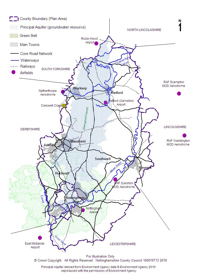
2.3. Nottinghamshire is part of the East Midlands, but also shares a boundary with South Yorkshire. Northern parts of Nottinghamshire therefore have significant employment, housing and business links with Sheffield, and the metropolitan areas of Barnsley, Rotherham and Doncaster. The more urbanised west of the County is also closely linked to neighbouring Derbyshire, with more rural eastern parts of the county having a similar character to neighbouring parts of Lincolnshire. In the south, Nottingham is a major regional centre with close physical links to the neighbouring cities of Derby and Leicester. Consequently there is a significant overlap of housing areas; business and employment between these three cities (see Plan 1 below).
Population
2.4. Nottinghamshire has a population of around 1,000,000 residents. Nottingham, in the south of the County, is one of the UK's eight Core Citiesand a major centre for employment, retail and tourism. Around two thirds of the County's population live in, or close to, Nottingham. Most of the remainder live in, or close to, the other main towns of Mansfield, Kirkby-in-Ashfield, Sutton-in-Ashfield, Hucknall, Worksop, Newark and Retford.
Transport and Communications
2.5. Road and rail links to the rest of the UK are generally good, especially via the main north-south routes of the M1, A1, A46 and direct rail links to London from Retford, Newark and Nottingham. Links to the M1 have been enhanced with the widening of the A453 into Nottingham.
2.6. Most freight, including minerals, is currently moved by road rather than rail although there is some use of the County's network of rivers and canals for transport. The River Trent, especially, is a major waterway flowing from Nottingham to Newark and then northwards to the Humber, forming part of the County's eastern boundary.
2.7. Although just outside the County, both East Midlands Airport at Castle Donington and Robin Hood Airport near Doncaster provide national and international passenger and freight services.
Employment, Economy and Resources
2.8. This connectivity makes the County an important centre for warehousing, distribution, and other service based industries, which are replacing the more traditional industries of coal-mining, textiles and manufacturing, especially around Mansfield, Worksop and Newark.
2.9. Here, the legacy of former coal mining and heavy industry has left a surplus of derelict land and opportunities for enterprise and redevelopment. Nottingham and its surrounds also provide a major centre for technology, financial, knowledge and science based industries. Away from the main urban areas, agriculture and forestry are no longer major employers but still make up much of the County's rural landscape, particularly to the south and east. Minerals and energy production are important in parts of the County, especially sand and gravel extraction from the Trent and Idle Valleys and the four major power stations along the River Trent.
2.10. Nottinghamshire's economy generally compares well to the rest of the UK, with key urban areas expected to be the focus of significant housing and commercial development in future. However, there are also wide inequalities in the rates of employment, income, education and skills across the County, most notably in former mining areas.
Green Belt
2.11. In Nottinghamshire the Green Belt covers land around Greater Nottingham, Nottingham City and rural village areas. It covers more than 43,000 ha and exists to prevent towns from merging, limit urban sprawl and to safeguard the countryside (see Plan 1 below). National policy states that minerals extraction is not inappropriate in the green belt provided the openness of the green belt is preserved and where it would not conflict with the purposes of including land in the green belt.
Landscape and Countryside
2.12. The County's landscape is characterised by rich rolling farmlands to the south, with a central belt of mixed woodland and commercial forestry, giving way to heathland in the north and open, flat agricultural landscapes to the east. Although agriculture is a relatively small industry today, large parts of the County are made up of good quality agricultural land with the highest quality (Grade 1) being concentrated in the northern part of the County. The six country parks around Nottinghamshire provide valuable areas of open space.
Nature
2.13. Nottinghamshire supports a wide range of important sites for nature conservation, including a Special Area of Conservation within Sherwood Forest, near Edwinstowe, that is of international importance. A large part of central Nottinghamshire is also being considered as a possible Special Protection Area for birds which would provide protection at the international level under European regulations. The quality of Nottinghamshire's natural environment has suffered in the past from the impacts of development and there has been a significant decline in biodiversity, with losses of ancient woodland, heathland, species-rich grassland, hedgerow and wetland habitats, as well as the species that these habitats support. Some of these historic declines are now being halted, and in some cases reversed, with neglected sites brought into positive management and new areas of habitat created as a result of the activities of partner organisations in the Nottinghamshire Biodiversity Action Group, by initiatives such as Environmental Stewardship and the English Woodland Grant Scheme, and as a result of restoration schemes. This action is being co-ordinated and quantified through the Nottinghamshire Local Biodiversity Action Plan.
Heritage
2.14. Nottinghamshire's heritage is very diverse. Creswell Crags on the Nottinghamshire-Derbyshire boundary has the most northerly Ice Age cave art in the world. The historic landscape of the Trent Valley is an important area for archaeological remains of prehistoric settlement. There is important evidence of Roman field patterns in the north of the County and the modern day A1 and A46 follow the line of old Roman routes. Evidence of Viking influence is apparent in many of the County's place names. Sherwood Forest boasts a unique heritage of folklore, monasticism and large country house estates (the Dukeries). The County has a fine collection of historic market towns including Worksop, Newark, Retford, Mansfield and Southwell. They are all rich in architectural and archaeological heritage. The Rivers Trent and Idle, which historically provided important cultural and trade links and the focus of many of our early settlements, are still relied on today by industry, agriculture and the County's power stations.
2.15. For hundreds of year's coal mining and other quarrying was very significant in the west of the County. Nottingham's industrial past was dominated by the textile industry throughout the 18th, 19th into the 20th centuries and has left a rich built heritage. The majority of Nottinghamshire's conservation areas, listed buildings, historic parks, and Scheduled Ancient Monuments are in good condition, but a proportion (around 10%) are in a vulnerable condition or situation.
Water, Soil and Air
2.16. Much of Nottinghamshire is underlain by important groundwater resources used for industry, agriculture and drinking water. The Rivers Trent and Idle also provide important surface water resources. Whilst water quality is good overall, there are problems with the level of nitrates in the soil in large parts of the County which can in turn affect water quality. The whole of north Nottinghamshire is therefore designated as a nitrate vulnerable zone.
2.17. Flood risk varies across the County and, although there are several areas at risk of localised surface flooding, the main risk comes from the River Trent, especially around Nottingham and Newark and in some of the outlying villages.
2.18. Air quality is generally good across the County but several Air Quality Management Areas (AQMAs) have been designated around Nottinghamshire because of known traffic and congestion problems.
Health
2.19. Overall health indicators are slightly lower than both the regional and national average although life expectancy has recently grown closer to the national average. There are also wide variations in life expectancy with a twelve year gap in average life expectancy between the least and most deprived wards. In some areas low levels of income, and high levels of unemployment and stress, are seen as having a significant impact on health and wellbeing. The main urban areas of Mansfield and Ashfield are worst affected, whilst more rural, affluent areas within Rushcliffe and Gedling generally fare far better in line with national trends. Obesity, amongst both children and adults is also a concern.
Climate
2.20. Parts of Nottinghamshire have already experienced more frequent and heavier flooding previously and, overall, this pattern is expected to continue. In common with the rest of the UK there is also an increased likelihood of higher average temperatures, drier summers, wetter winters and more frequent and extreme storms.
Plan 1: Overview of the Plan area
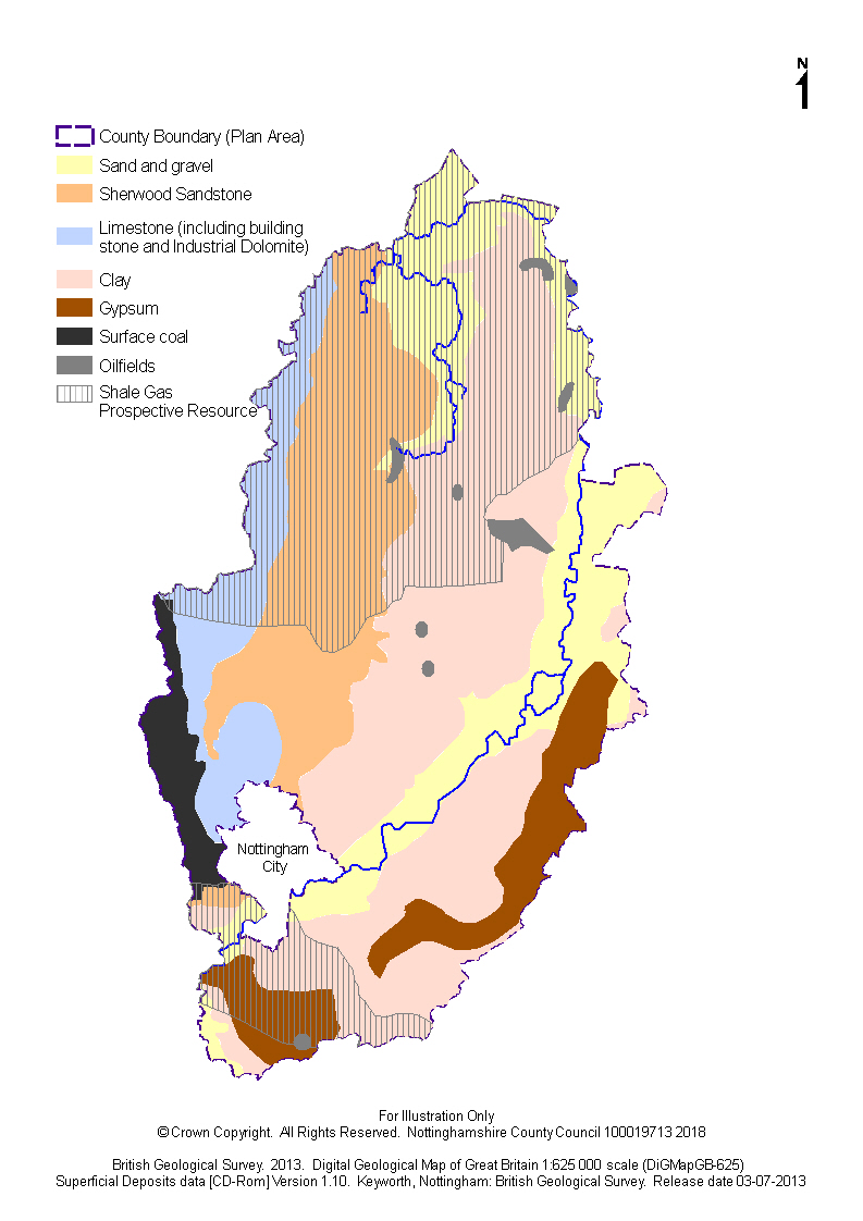
Nottinghamshire's mineral resource and industry
2.21. Nottinghamshire is rich in minerals and most widely known for its coal mining industry which has had a major impact on the social and economic development and environment of many parts of the County. The legacy of the coal industry is still very evident; the most visible reminders are the large spoil tips, many of which have been restored but some still present environmental issues. Most former colliery sites have now been redeveloped to provide new employment opportunities for communities that were hit hard with the closure of collieries.
2.22. Today, sand and gravel is the biggest extractive industry in the County. Most quarries work the river deposits found in the Trent and Idle valleys, although Sherwood Sandstone is also exploited. This activity has transformed large areas of the Trent and Idle Valleys into wetlands and in doing so has changed the landscape character of the area. Some former workings are now used for sports and recreation and others have become important wildlife habitats. As the County has suffered from a loss of habitats, sand and gravel restoration schemes have had a very significant role in redressing the balance.
2.23. Gypsum is another major minerals industry in Nottinghamshire, and has been extensively mined in the south of the County and quarried between Newark and Kilvington. The associated plasterboard and plaster works that these mineral operations support are important local employers although few are actually directly employed in the extractive process itself.
2.24. Other minerals worked are brick clay, silica sand, building stone, aggregate limestone, and oil. Some of these minerals also support locally important associated industries such as brick works.
2.25. Building stone was worked much more extensively in the past and has contributed towards the traditional character of many villages and historic buildings. Today extraction is limited to just one small quarry.
2.26. Nottinghamshire has potential mineral resources that have not been exploited but which could be in the future. This includes industrial dolomite found in a small area in the north west of the County and potential shale gas resources which are thought to exist in the north and the south of the County.
Wider issues
2.27. There is a significant movement of minerals both in and out of the County which provides opportunities to work with other Mineral Planning Authorities to manage these movements and minimise the environmental impacts of the extraction.
2.28. Plan 2 illustrates the geological resource of Nottinghamshire.
Plan 2: Nottinghamshire's mineral resources
Vision
2.29. The Vision for managing minerals seeks to address the issues facing the Plan Area and take into account the views of local communities and other stakeholders as well as supporting the delivery of national planning policies. The broad aims are then developed in more detail in the Strategic Objectives, the policies, and the Implementation section.
"Over the plan period to 2036minerals will continue to be used as efficiently as possible across Nottinghamshire. Minerals are a valuable natural resource and should be worked and used in a sustainable manner and where possible reused to minimise waste
Mineral development will be designed, located and operated to ensure that environmental harm and impacts on climate change are minimised.
Within geological constraints, mineral development will be concentrated in locations that offer the greatest level of accessibility to the major markets and growth areas and to sustainable transport nodes to encourage sustainable patterns and modes of movement.
Nottinghamshire will continue to provide minerals to meet its share of local and national needs. Sites will be available to support the economic, social and environmental benefits of sustainable growth. Mineral reserves, and minerals related infrastructure will be identified and safeguarded against inappropriate development. Consumption will be minimised, by promoting the use of secondary and recycled minerals.
Quarries will be designed, operated and managed in ways which help to reduce flood risk, particularly in the Trent Valley flood plain, manage surface water sustainably and maintain or enhance water quality.
All mineral workings will contribute towards 'a greener Nottinghamshire' by ensuring that the County's diverse environmental assets are protected, maintained and enhanced through appropriate working, restoration and after-use and by ensuring that proposals have regard to Nottinghamshire's historic environment, townscape and landscape character, biodiversity, geodiversity, agricultural land quality and public rights of way. This will result in improvements to the environment, contribute to landscape-scale biodiversity delivery, including through the improvements to existing habitats, the creation of large areas of new priority habitat, and the re-connection of ecological networks, with sensitivity to surrounding land uses.
The quality of life and health of those living, working in, or visiting Nottinghamshire will be protected."
Strategic Objectives
2.30. The following objectives have been identified as central to achieving the delivery of the spatial vision for future Minerals development in Nottinghamshire:
SO1: Improving the sustainability of minerals development
Ensure more efficient exploitation and use of primary mineral resources by minimising waste, increasing levels of aggregate recycling and the use of alternatives from secondary and recycled sources. Secure a spatial pattern of mineral development that efficiently delivers resources to markets within and outside Nottinghamshire. Prioritise the improved use or extension of existing sites before considering new locations. Make use of sustainable modes of transport.
SO2: Providing an adequate supply of minerals
Assist in creating a prosperous, environmentally sustainable and economically vibrant County through an adequate supply of all minerals to assist in economic growth both locally and nationally. Provide sufficient land to enable a steady and adequate supply of minerals over the plan period. Assist in creating a sustainable and economically vibrant County through providing an adequate supply of all minerals to assist in economic growth both locally and nationally.
SO3: Addressing climate change
Minimise and mitigate the impact of mineral developments on climate change by encouraging efficient ways of working including reductions in transport and onsite machinery emissions. Reduce existing and future flood risks linked to, and aid in adaptation to, climate change through good quarry design and operation, water management, location of plant and appropriate restoration, particularly for quarries in the Trent Valley flood plain. Contribute to climate change adaptation by relinking fragmented habitats and creating new areas of habitat to allow the migration and dispersal of species.
SO4: Safeguarding of mineral resources
Protect the County's potential mineral resources of economic importance from development which would prevent or hinder their future use.
SO5: Minimising impacts on communities
Minimise the adverse impacts on Nottinghamshire's communities by protecting their quality of life and health from impacts such as traffic, visual impact, dust, water resources etc. Make sure that local people have the opportunity to be involved in decisions about new mineral developments by providing information, encouraging wider involvement and targeting key groups or individuals where appropriate. Protect and enhance rights of way and access to open space.
SO6: Protecting and enhancing natural assets
Conserve and enhance Nottinghamshire's natural environment, including its distinctive landscapes, habitats, geology, wildlife species and ecological health of water bodies by avoiding, minimising and mitigating potential negative impacts. Maximise biodiversity gain by creating new habitats at a landscape-scale through mineral restoration schemes which take in to account the Council's priority for biodiversity-led restoration, focusing on priorities set out in the Nottinghamshire Local Biodiversity Action Plan, in particular meeting reed bed and floodplain grazing marsh targets through sand and gravel restoration schemes, and heathland targets through sandstone restoration schemes, and achieving the targets set out in the Water Framework Directive objectives. Support minerals development that will provide long term enhancements to landscape character and which avoids damaging the highest quality landscapes. Appropriate restoration will result in a net gain for biodiversity through the creation of new ecologically valuable habitats, and will contribute to the delivery of biodiversity at a landscape-scale and the enhancement of ecological networks.
SO7: Protecting and enhancing historic assets
Protectand where appropriate enhance Nottinghamshire's distinct historic environment. Ensure heritage assets (archaeological, historic buildings, settlements, landscapes, parks and gardens) and their settings are adequately protected and where appropriate enhanced. Recognise the important role of locally sourced building stone in the repair of heritage assets and in maintaining local distinctiveness.
SO8: Protecting agricultural soils
Support minerals developments that will safeguard the long-term potential of best and most versatile agricultural soils.
Key Diagram
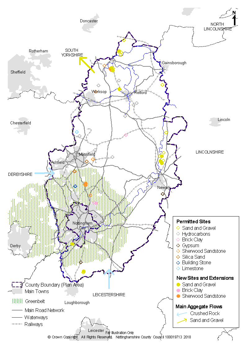
2.31. The components of the spatial strategy are illustrated on the Key Diagram below (Plan 3). It shows the main supply sources for aggregates and the principal constraints.
2.32. The Key Diagram is intended to be a diagrammatic interpretation of the Spatial Strategy set out in this document and is not intended to portray any specific site activity or proposal with spatial accuracy.
2.33. The remaining sections of the Plan develop the Spatial Strategy's principles and objectives. Specific details relating to the policies are shown on the Policies Map.
(51) Question 1
What do you think to the draft vision and strategic objectives set out in the plan?