Pre- Submission Draft Waste Local Plan
4. Overview of the Plan Area
4.1. To help inform the plan process we have developed a 'spatial portrait' of Nottinghamshire and Nottingham, setting out the key environmental, geological, geographic, social and economic influences found in the Plan Area
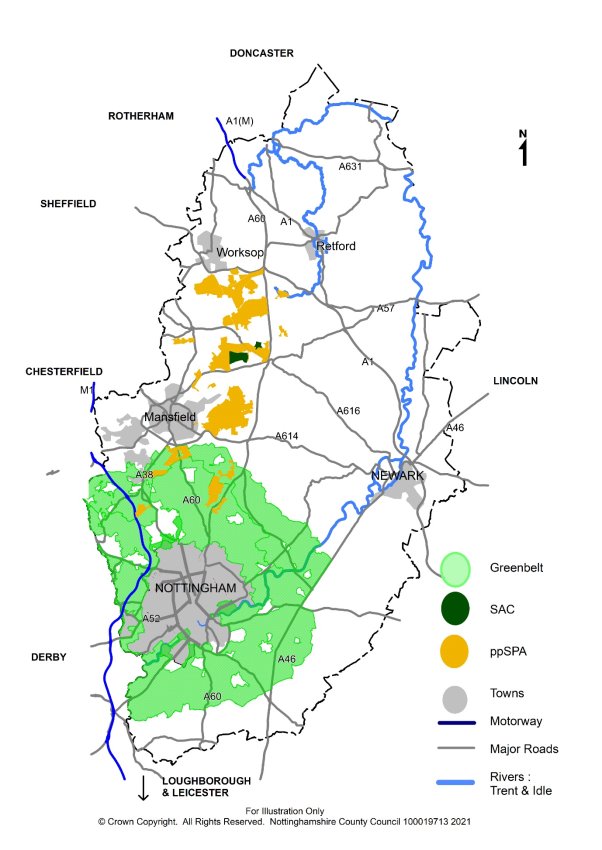
4.2. The Plan area is part of the East Midlands and shares a boundary with South Yorkshire. Northern parts of Nottinghamshire therefore have significant employment, housing and business links with Sheffield and the metropolitan areas of Barnsley, Rotherham and Doncaster. The more urbanised west of the County is closely linked to neighbouring Derbyshire, with more rural eastern parts of the County having a similar character to neighbouring parts of Lincolnshire. In the south, Nottingham is the major regional centre with links to the neighbouring cities of Derby and Leicester. Consequently, there is a significant overlap of housing areas, business and employment between these three cities (see Plan1 below).
4.3. Nottingham City is a designated Core City of national importance and consists of a very compact and a high-density urban area. Nottingham City has a very tight urban boundary and is surrounded by several borough and district councils and their connecting urban areas.
(1) 4.4. There are around 823,000 people living in Nottinghamshire County and 330,000 in Nottingham City. Around two thirds of the overall population live in, or around, Nottingham which is a major centre for employment and retail. The remainder live in, or close to, the larger towns of Mansfield, Kirkby in Ashfield, Sutton in Ashfield, Hucknall, Worksop, Newark and Retford and larger villages. Outside these areas, the rest of the County is largely rural with scattered small villages, farmland, woodland and commercial forestry.
(1) 4.5. The County's landscape is characterised by rich rolling farmlands to the south, with a central belt of mixed woodland and farmland, giving way to heathland of Sherwood in the north-west and open, flat agricultural landscapes dominated by the River Trent to the east, and the flat low lying agricultural landscape of the Humberhead Levels to the north Nottinghamshire also supports a wide network of important sites for nature conservation, the most important focused within Sherwood Forest, to the north of Mansfield. This includes a Special Area of Conservation and possible future Special Protection Area, both of which hold international status.
(1) 4.6. Nottinghamshire is well known for its historic past, in particular for its link to the tales of Robin Hood but the areas heritage is much more diverse, with assets spanning thousands of years; from cave art found at the Creswell Crags on the Nottinghamshire- Derbyshire Border to medieval caves, taverns and castle found in Nottingham's city centre as well as several historic market towns full of heritage assets. The industrial past of coal mining, particular in the West of the County, and the textile industry throughout the 18th and early 19th into the 20th centuries has left a rich built heritage. The majority of Nottinghamshire's conservation areas, listed buildings, historic parks, and Scheduled Ancient Monuments are faring well, but a proportion (around 10%) are in a vulnerable condition or situation.
4.7. Road and rail links to the rest of the UK are generally good. The area is connected to the M1 and the national motorway network via the A453 to junction 24, the A52 to junction 25 and the A610 to junction 26 and the A38 to Junction 28. The A52 provides a trunk road connection from Derby to Nottingham including to the A46 which runs between the M1 north of Leicester to the A1 at Newark. Orbital movements in Nottingham are less well accommodated with there being only a partial ring road (A52 and A6514). To the north of the County the A614 links Nottingham to the A1 and A60 with wider links to Mansfield, which is also linked via the A617 to Newark.
4.8. Nottinghamshire's economy generally compares favourably with the rest of the UK, and some of our urban areas are expected to be the focus of significant housing and commercial development in the future. However, there are wide inequalities in the rates of employment and income across the plan area, most notably in the former mining areas to the north and west and within parts of Nottingham City. These areas often also experience inequalities in health, education and skills.
4.9. Mansfield, Worksop and Newark are important centres for warehousing and distribution whilst service, technology and research-based industries tend to cluster in around Nottingham. The energy industry also has a role with four power stations along the River Trent, however, coal powered power stations are due to close or be replaced by 2025. Elsewhere, agriculture and forestry are no longer major employers but still make up much of the County's rural landscape.
4.10. As a regional economic hub, Nottingham City is the main work destination for the majority of residents living within the city and surrounding areas and there is a strong focus for pharmaceuticals and optical goods, manufacturing, ICT technology and finance and banking. Approximately 226,000 people are employed within Nottingham City.
4.11. Flood risk, particularly in the Trent Valley and along its tributaries, presents planning and environmental issues which is a significant constraint to most forms of built development. The impacts of future climate change could result in higher rainfall and more extreme flood events. All of Nottingham City has been designated an Air Quality Management Area.
Plan 1 – Plan Area