
Minerals Local Plan Sustainability Appraisal Scoping Report
(1) Consultation Questions
Chapter 1: Introduction
1. Has the requirement for, and purpose of, SEA and SA, been adequately explained?
Chapter 2: Methodology
2. Has the methodology been adequately described and is it considered to be appropriate?
Chapter 3: Other relevant Plans, Policies and Programmes
3. Have all the relevant documents been listed in Appendix 1? If not, what others should be included?
4. Have the key messages from the documents review been correctly identified in Table 1? If not, what should be added, amended or deleted?
5. Have the implications for the SA framework been accurately assessed in Table 1. If not, what should be added, amended or deleted?
Chapter 4: Baseline information and characteristics of Nottinghamshire
6. Has all the relevant baseline data been included in Appendix 2? If not, what else should be included?
7. Are there any inaccuracies in the baseline data?
8. Have all the key characteristics of Nottinghamshire been adequately described?
Chapter 5: Sustainability issues
9. Have all the relevant sustainability issues been correctly identified in Table 2? If not, what amendments are required?
10. Has the significance of the sustainability issues been correctly assessed in Table 2? If not, what amendments are required?
11. Have the ways in which the Minerals Local Plan can influence the sustainability issues been adequately addressed in Table 2? If not, what amendments are required?
Chapter 6: Developing our sustainability objectives (the SA framework)
12. Do the SA objectives adequately cover the sustainability issues which are relevant to the Minerals Local Plan? If not, what amendments are required?
13. Are the decision-making criteria and proposed indicators appropriate? If not, what amendments are required?
14. Do you have any other comments on this Scoping Report?
(6) 1. Introduction – What is Sustainability Appraisal?
1.1 This scoping report represents the first stage of the Sustainability Appraisal (SA) process which was introduced through the Planning and Compulsory Purchase Act 2004. When complete the SA will ensure the County Council integrates sustainable development principles into all the relevant documents produced as part of the Minerals Local Plan process.
1.2 The National Planning Policy Framework (March 2012) (NPPF) states that the purpose of the planning system is to contribute to the achievement of sustainable development. Sustainable development has a number of different definitions however for the purpose of the SA process the definition in the Government's 'Securing the future - Delivering UK sustainable development strategy' (March 2005) has been used. It states that:
"The goal of sustainable development is to enable all people throughout the world to satisfy their basic needs and enjoy a better quality of life, without compromising the quality of life of future generations. This will be pursued in an integrated way through a sustainable, innovative and productive economy that delivers high levels of employment; and a just society that promotes social inclusion, sustainable communities and personal wellbeing. This will be done in ways that protect and enhance the physical and natural environment, and use resources and energy as efficiently as possible."
1.3 The NPPF refers to the UK Sustainable Development Strategy's five guiding principles for sustainable development:
- Living within environmental limits
Respecting the limits of the planet's environment, resources and biodiversity, to improve our environment and ensure that natural resources needed for life are unimpaired and remain so for future generations.
- Ensuring a strong, healthy and just society
Meeting the diverse needs of all people and future communities, promoting personal well-being, social cohesion and inclusion and creating equal opportunity for all.
- Achieving a sustainable economy
Building a strong, stable and sustainable economy which provides prosperity and opportunities for all, and in which environmental and social costs fall on those who impose them (polluter pays), and efficient resource use is incentivised.
- Using sound science responsibly
Ensuring policy is developed and implemented on the basis of strong scientific evidence, whilst taking into account scientific uncertainty (through the precautionary principal) as well as public attitudes and values.
- Promoting good governance
Actively promoting effective, participative systems of governance in all levels of society, engaging people's creativity, energy, and diversity.
The NPPF emphasises that the planning system has a role to play in each of the three mutually dependent dimensions of sustainable development and that gains in all three of these should be sought simultaneously:
- "an economic role – contributing to building a strong, responsive and competitive economy, by ensuring that sufficient land of the right type is available in the right places and at the right time to support growth and innovation; and by identifying and coordinating development requirements, including the provision of infrastructure;
- a social role – supporting strong, vibrant and healthy communities, by providing the supply of housing required to meet the needs of present and future generations; and by creating a high quality built environment, with accessible local services that reflect the community's needs and support its health, social and cultural well-being; and
- an environmental role – contributing to protecting and enhancing our natural, built and historic environment; and, as part of this, helping to improve biodiversity, use natural resources prudently, minimise waste and pollution, and mitigate and adapt to climate change including moving to a low carbon economy."
1.4 These principles form the basis for delivering sustainable development within the UK. Nottinghamshire County Council has a vital role in supporting the aims of these principles in preparing its own policies and proposals for future development.
The relationship between Sustainability Appraisal and Strategic Environmental Assessment
1.5 When preparing the various policy documents that make up our statutory development plan (the Plan), every authority must carry out an environmental assessment in accordance with the requirements of European Directive 2001/42/EC on the 'assessment of the effects of certain plans and programmes on the environment'. This is known as the Strategic Environmental Assessment or SEA Directive.
1.6 Within the UK the concept of SEA has been broadened to include an assessment of economic and social impacts as well the specific environmental issues identified in the SEA Directive. This wider process of Sustainability Appraisal therefore incorporates all of the requirements of the SEA Directive. Throughout this document, the term SA is used to refer to the joint SA/SEA process and the methodology used incorporates all of the requirements of SEA. Table 7 in Chapter 6 shows how this report meets the relevant SEA requirements.
Other appraisals
1.7 The findings of the SA process will be considered in conjunction with those of a number of other appraisals, including the following. A Strategic Flood Risk Assessment will provide information on potential sources of flooding and mitigation; a Transport Assessment will examine likely transport impacts of proposed sites; a Health Impact Assessment will consider the implications of the Plan for health and wellbeing; and an Equality Impact Assessment will examine the impacts of the Plan on the whole community. In addition, as Nottinghamshire has a site of international importance for nature conservation, the Sherwood Forest Special Area of Conservation (SAC), we are also required to carry out what is known as a Habitats Regulations Assessment under separate legislation, which may lead to the need to undertake a more detailed Appropriate Assessment[1].
What is the purpose of SA?
1.8 The purpose of SA is to promote better integration of sustainability considerations into plan preparation and adoption. SA is therefore an integral part of good plan making and should not be seen as a separate activity. It is an ongoing and iterative process that will help us to identify and report on the likely significant effects of the Minerals Local Plan and the extent to which implementation of the Plan will achieve the social, environmental and economic objectives by which sustainable development can be defined.
1.9 The SA process and the various stages of the plan making process are closely interlinked. The SA process will be carried out in accordance with current Government guidance[2].
Purpose of the SA Scoping Report
1.10 The integration of sustainability considerations into the preparation and adoption of plans is the key focus of the SA process.
1.11 The Scoping Report lays the foundation for the whole SA process and focuses on the context of the Plan, which in this case is the Minerals Local Plan.
1.2 The Scoping Report is also the mechanism for developing a sound and robust SA framework and appraisal methodology. Hence the Scoping Report forms the basis for the appraisal and production of the SA Report. The Scoping Report details:
• Other policies, plans and programmes influencing the Plan and SA, including the international, national and local policy context;
• Baseline information and key sustainability issues, including economic, environmental, social and spatial factors;
• Development of the SA framework and objectives;
• Methodology for testing the emerging Plan's vision, objectives, policies and development options, and appraising potential effects of the Plan, against the SA framework.
The role of our minerals policy documents
1.13 Every local authority must prepare a formal development plan for its area setting out its priorities for future development, where this should be located and key environmental constraints that should be addressed. The County Council has a specific duty to do this for minerals. We will therefore be preparing a series of policy documents to set out how much development we want to see and where. You can find full details of the documents we are preparing on our website as shown below.
Community Involvement in SA
1.14 Community involvement, including the general public, interest groups, statutory bodies, local businesses and the minerals industry, is a key part of the planning process.At this stage, the only formal requirement is to consult the Environment Agency, Natural England and Historic England. These organisations will give their views on the work that has been carried out so far and will continue to provide advice on future stages of the appraisal. Other comments on the Scoping Report are welcome but can only be treated informally at this stage.
Further information
1.15 If you would like any further information on this report or the preparation of the Minerals Local Plan please contact the Planning Policy Team at Nottinghamshire County Council on 0300 500 80 80 or email planning.policy@nottscc.gov.uk . Full contact details are also provided at the end of Chapter 6 of this report. The information in this report can be made available in alternative formats and languages if required.
Consultation question:
- Has the requirement for, and purpose of, SEA and SA, been adequately explained?
(5) 2. Methodology
Carrying out SA
2.1 Government guidance on carrying out SA describes the production of a Scoping Report as 'Stage A: Setting the context and objectives, establishing the baseline and deciding on the scope', which involves five key stages. These are set out in Figure 1 below and this report has been structured according to these key stages.
Figure 1. Preparation of Scoping Report
|
Identifying other relevant policies, plans and programmes, and sustainability objectives |
|
Collecting baseline information |
|
Identifying sustainability issues and problems |
|
Developing the SA framework |
|
Consulting on the scope of the SA |
2.2 Information and evidence gathering is therefore the starting point for any SA in order to understand the current social, environmental and economic situation and possible future trends. The focus of the initial information gathering stage is therefore a review of all other relevant plans, programmes and policies (as set out in Appendix 1) and the collection of baseline environmental, social and economic data (as set out in Appendix 2). This will help to shape our future policies and proposals.
2.3 This work has been carried out 'in-house' using our own environmental information where available, but also relies heavily on data from other agencies and organisations which has helped to refine both the baseline data and the detailed objectives that will underpin this appraisal process.
Key findings and draft SA objectives
2.4 The key messages from the documents review are set out in Chapter 3 and Table 1, which identifies the implications for the SA framework, and the baseline information and characteristics of Nottinghamshire are described in Chapter 4.The key sustainability issues identified, together with their implications for the Minerals Local Plan, are summarised in Table 2. These form the basis of the draft SA objectives.
Limitations of the SA process
2.5 Part of the SA process is to establish what information is currently available and whether there is other information that should be collected in future. This involves a wide range of organisations which may hold different sets of data. The data they hold may not always be comparable or it may not have been collected at regular intervals. This can make it difficult to identify significant trends. Considerable progress is being made to collate this information so that it is up to date and accessible, but it is likely that the way data is collected, interpreted and monitored will improve over time. Future stages of SA work will take account of any relevant changes.
Future Timetable
2.6 The programme for preparing new documents and carrying out the relevant SA work will be kept up to date on the County Council's website at www.nottinghamshire.gov.uk.
Consultation question:
- Has the methodology been adequately described and is it considered to be appropriate?
(4) 3. Other relevant Plans, Programmes and Policies
(1) Introduction
3.1 The purpose of reviewing other plans, programmes and policies is to identify relevant sustainability objectives and ensure that the aims and objectives of the Minerals Local Plan are consistent with the purpose and aims of these strategies and plans. It is important to identify where there may be potential conflicts and also where our own minerals policies or proposals could help contribute to the aims of other plans.
3.2 The review has looked at relevant documents, including legislation, plans, guidance and strategies, at the international, national and local level. These are listed in full in Appendix 1. The key messages from this review are set out in Table 1 below and have been carried through into the set of appraisal objectives developed to help assess the likely effects of the Plan (see Chapters 5 and 6).
3.3 The key messages highlighted below are those which are considered relevant to minerals as not all issues covered in other appraisals (i.e. at the district/borough level) will be relevant.
(8) Table 1: Key messages from the documents review
|
Key messages |
Source of information |
Implications for SA Framework |
|
Natural environment and biodiversity
|
|
Requires objectives to protect and enhance biodiversity and habitats at all levels. |
|
Soil
|
|
Requires objectives to protect high quality agricultural land and minimise disturbance / damage and pollution to soils. |
|
Water
|
|
Requires objectives to protect and improve water quality. |
|
Flood risk
|
|
Requires objectives to minimise flood risk by locating new developments and associated plant in the most suitable (lowest risk) areas. |
|
Historic and cultural heritage
|
|
Requires objectives to conserve and enhance heritage assets of all types and their settings, and where protection of archaeological remains is not possible ensure detailed records are taken. |
|
Landscape and countryside
|
|
Requires objectives to protect landscape and townscape, and where possible enhance them through high quality restoration schemes. |
|
Air Quality
|
|
Requires objectives to prevent pollution and protect air quality. |
|
Climate Change
|
|
Requires objectives to reduce greenhouse gas emissions that contribute to climate change, and to ensure that new development is able to cope with the effects of climate change. |
|
Transport
|
|
Requires objectives to reduce the impact of transport by encouraging alternative, more sustainable forms of transport and efficient use of the highway network. |
|
Health
|
|
Requires objectives to improve health by minimising pollution and nuisance from sites and providing opportunities for recreation. |
|
Sustainable communities
|
|
Requires objectives to ensure communities have the opportunity to participate in the production of plans and that new development minimises its impact on its surroundings. |
|
Minerals
|
|
Requires objectives to maintain an adequate supply of minerals, make efficient use of minerals and minimise the local impacts of minerals development. |
|
Waste
|
|
Requires objectives to encourage more efficient use of land and resources. |
|
Economy and employment
|
|
Requires objectives to maximise employment from mineral activities and maintain an adequate supply of minerals. |
|
Energy
|
|
Requires objectives to minimise energy usage and encourage alternative energy sources. |
|
Land use
|
|
Requires objective to maximise the use of previously developed land where it does not compromise biodiversity and environmental assets. |
Consultation questions:
3. Have all the relevant documents been listed in Appendix 1? If not, what others should be included?
4. Have the key messages from the documents review been correctly identified in Table 1? If not, what should be added, amended or deleted?
5. Have the implications for the SA framework been accurately assessed in Table 1. If not, what should be added, amended or deleted?
(5) 4. Baseline information and characteristics of Nottinghamshire
(1) Introduction
4.1 It is important to have a good understanding of the current situation in terms of the social, economic and environmental wellbeing of Nottinghamshire. This helps to highlight any problems which the Minerals Local Plan should seek to address. It also provides a baseline of information against which to predict and subsequently monitor the effects of our policies.
4.2 A key part of the SA process is that each of the objectives is underwritten with comprehensive and up-to-date baseline information, using a reliable set of indicators that can be monitored over time. The indicators that have been used for each objective are shown in Table 4 (Chapter 6).
4.3 By comparing our own position to what is happening across the region, and nationally, we can establish where we are doing well and what needs to improve.
4.4 The baseline data collected for this report is set out in Appendix 2. This shows the most recent data for Nottinghamshire along with regional and national comparisons, where available. The table also includes any relevant targets and provides a commentary on the current position and any noticeable trends.Whilst not all of the information is currently available, the data will continue to be refined and updated as part of the ongoing SA process.
4.5 The following paragraphs identify the key environmental, social, economic and physical characteristics of Nottinghamshire that have been identified from the baseline data and other information that is available.
(3) Key characteristics of Nottinghamshire
Area and population
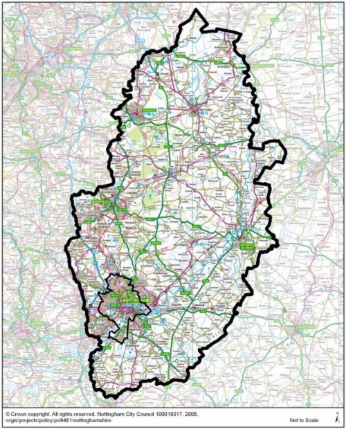
4.6 Nottinghamshire is a large county, covering 2,085 square kilometres of the East Midlands area. It is made up of three distinct areas comprising the relatively affluent suburbs around Nottingham; the north-west towns and villages which share a coal-mining and textile heritage; and more rural areas to the south and east which are characterised by prosperous market towns and villages along the Trent Valley. Nottingham, to the south of the County, is one of the UK's eight core cities and a major regional centre for the East Midlands. Although the administrative boundary of the City is drawn quite tightly, the extent of the built up area, its associated housing market and travel to work patterns reflect a wider influence over a more general area known as Greater Nottingham. This includes part of Ashfield, reaching north up to Hucknall and all of Nottingham's other surrounding districts which house the City's key suburbs. Outside Greater Nottingham, the main towns are Mansfield, Sutton-in-Ashfield, Kirkby-in-Ashfield, Newark, Worksop and Retford.
4.7 Nottinghamshire's overall population is just over 800,000, when combined with the city of Nottingham this totals over 1 million people with around two thirds of these living in, or within easy reach of, Nottingham. Administratively, there are seven district and borough councils within the County Council area whilst Nottingham City Council carries out both the district and county functions as a unitary authority.Geographically and economically there are close links between the three cities of Derby, Leicester and Nottingham and the neighbouring towns such as Chesterfield and Doncaster. The County shares borders with Yorkshire, Rotherham and Doncaster to the north, Derbyshire to the west, Leicestershire to the south and North Lincolnshire and Lincolnshire to the east.
Transport
4.8 There are good transport links to the rest of the UK, especially via the main north-south routes of the M1, A1 and the East Coast and Midland Mainline rail lines. Sections of the A46 have been widened, which should improve access to Leicester and Lincoln and improvements to the A453 link into Nottingham from the motorway are complete. Key transport concerns include congestion and air quality and the effect this may have on the rate of climate change. Congestion is improving but is focussed on the main routes into Nottingham, Mansfield, Newark and Worskop. Air pollution within Nottinghamshire is concentrated along major transport corridors such as the A1 and M1 and around the main urban areas, particularly within the Greater Nottingham area where ten AQMAs have been designated. Nottinghamshire supplies minerals locally, regionally and nationally. The majority is currently transported by road although some desulphogypsum is transported by rail and some sand and gravel is moved by barge.
Natural Environment and Biodiversity
4.9 Nottinghamshire has a wide range of important wildlife habitats and species although it has suffered significant losses due to the effects of industrialisation and coal mining, urban expansion, intensive agriculture and commercial forestry. Large areas of semi-natural woodland have been lost along with traditional hedgerows and species-rich grasslands, plus 90% of the County's lowland heathland had been lost by early in the last century. Cumulatively, this has seen a dramatic reduction in biodiversity across the County and Nottinghamshire's Local Biodiversity Action Plan (LBAP) lists over 900 species and 25 habitats that are of conservation concern. However these downward trends are now being halted or reversed through pro-active management schemes, including the high quality restoration of minerals sites to create new habitats. Examples include the wetlands the Idle Valley Nature Reserve near Sutton and Lound, the creation of healthland habitats within Sherwood Forest and woodland planting across the Greenwood Community Forest.
4.10 Although there are comparatively fewer areas of designated nature conservation value here than in other parts of the East Midlands and the UK as a whole, Nottinghamshire still maintains important populations of key species such as great crested newt ,water vole, white-clawed crayfish along with populations of notable invertebrates. There are also significant areas of heathland and acid grassland sites within Sherwood Forest which contains the only internationally important conservation site within the County - the Birklands and Bilhaugh Special Area of Conservation (SAC). However part of the County is now being considered as a possible Special Protection Area (SPA) for birds on the basis of its significant populations of nightjar and woodlark. The County has 1 National Nature Reserve and 67 Sites of Special Scientific Interest (SSSIs) which account for only 1.53% of the County area, compared to 8.39% nationally[3]. The condition of these sites is improving but still falls short of meeting the national target of 95% of SSSIs being in favourable or recovering condition. There are 59 Local Nature Reserves (LNRs) and more than 1300 local Sites of Importance for Nature Conservation (SINCs) also known as Local Wildlife Sites (LWSs), of which only around 20% are known to be in positive conservation management. In addition, there are areas of LBAP habitats that fall outside these designated sites, including species-rich grasslands, woodlands, wetlands and waterways, and other features that make up the wider network of green infrastructure across the County.
Historic and cultural heritage
4.11 Nottinghamshire has a long and rich heritage with evidence of early Iron Age and Bronze Age settlements in northern and central parts of the County, and a significant Roman settlement at Mansfield. Important Viking finds have also come to light within Sherwood Forest. The County remained important through the Middle Ages and medieval times with royal castles and hunting grounds and enduring links to the legend of Robin Hood. Market towns at Worksop, Retford, Newark and Mansfield expanded during these times and the dissolution of the monasteries and forest clearances paved the way for the creation of large estates such as Clumber and Rufford. Nottingham and Newark played key roles in the skirmishes and sieges of the Civil War.
4.12 Nottinghamshire also has a long association with textile and clothing production with early cottage industries being subsumed by the spread of industrialisation and the mass development of factories, canals and railways. Throughout our history the River Trent has provided important trade links with many settlements along its banks. It also remains an important source of power for industry, with three major power stations along the Trent Valley. Just as important as the Industrial Revolution, have been the changes in agriculture which have changed our landscape and helped to build the trade in wool and establish the rich merchants whose philanthropy then founded many of our important civic buildings. Nottingham's Lace Market area is a prime example of this historic legacy. Coal mining has also played a major part in our development as the power behind our industrialisation and a major employer until recent times.
4.13 Much of our preserved heritage dates from the Middle Ages onwards and can be seen in the large country estates, market towns and medieval castles and historic field patterns. From more recent times, the County has a large collection of industrial archaeology including frame-knitters cottages, lace factories and mills along with our former mining villages with their characteristic long terraces of workers' housing and skyline of colliery headstocks and spoil heaps.
4.14 Across Nottinghamshire there are over 4500 listed buildings. 10% of Grade I and II* listed buildings are considered to be at risk. This is worse than the situation nationally, but better than the situation across the East Midlands region. There are also 142 conservation areas, 19 registered parks and gardens and 158 Scheduled Ancient Monuments.
Landscape, countryside and townscape
4.15 Nottinghamshire is a generally flat county with rich rolling farmlands to the south, a central belt of mixed woodland and commercial forestry with patches of heathland and oak-birch woodland to the north, open agricultural landscapes to the east and pasture and woodland on the coal measure and Magnesian limestone to the west. Key landscape features are the wide, flat river valleys with extensive farmland, and large, historic market towns such as Newark and Retford. More scattered rural villages are settled within the gently rolling Wolds to the south of the County. The concentrated urban development around Nottingham and the impact of major transport corridors such as the M1 and A1, along with the legacy of coal mining in the west of the County, reflect more recent industrial influences. The County's two main rivers are also significant landscape features and show the evidence of continuing sand and gravel extraction with extensive areas of former sand and gravel working that have been restored to open water - including the National Water Sports Centre at Holme Pierrepont. The County's three remaining power stations are also dominant features along the line of the Trent flood plain.
4.16 Much of our countryside and open space remains threatened by the impacts of intensive agriculture, urbanisation and future mineral working and many parts of the County have suffered from the historic loss of hedgerows and traditional field patterns. Urban fringes, especially in the Green Belt around Nottingham, face significant pressure for urban expansion to deliver new housing and employment opportunities.Likely future changes to our climate may also alter the appearance of our landscape as the local temperature and water levels will dictate what kinds of vegetation can be sustained.
Climate
4.17 Although local data is hard to source, Nottinghamshire's climate is likely to follow the patterns generally being observed and predicted across the UK. We have already started to see increased incidences of flooding and we can expect a general pattern of increased rainfall, hotter and more unsettled summers and increased flooding. There will also be increased incidents of freak weather including flash floods, high winds and storms. Overall greenhouse gas emissions are falling, especially for Co2, but some of these changes cannot now be reversed. Mineral working is not a major source of emissions although transporting minerals will contribute to overall transport emissions and the use of fossil fuels for energy is another major contributor.
Air quality
4.18 Air quality is of major importance for climate and health as well as maintaining the diversity and quality of our natural environment. Nottinghamshire's air quality is generally improving but air pollution along major transport corridors such as the A1 and M1 and around the main urban areas is still a concern. Nine Air Quality Management Areas (AQMAs) have been designated on main routes into Nottingham because of the No2 levels from traffic, and a tenth one has been designated for SO2. Emissions of Co2 are mainly from commercial and industrial sources, especially from our power stations. Whilst there has been a slight overall reduction in Co2 over time (with some fluctuation), the actual levels vary quite widely between districts. Bassetlaw and Newark and Sherwood both have a much higher rate than Gedling for example.
Water
4.19 A large part of Nottinghamshire overlies the Sherwood Sandstone Aquifer which is one of the largest groundwater resources in the UK. This is now fully developed and water conservation measures are being put in place to manage future abstraction levels. Whilst water supplies are likely to be sufficient to meet the current levels of planned growth, they are unlikely to support any additional increases and may be a constraint on the exact locations of new development.
4.20 Our two main rivers are the Trent and Idle which have both seen extensive mineral working for sand and gravel and are an important part of the County's landscape, heritage and natural environment. Whilst there has been a slight improvement in river quality, this is still marginally lower than the regional and national figure. Nottinghamshire is also vulnerable to nitrate pollution, especially in north Nottinghamshire around Worksop, although large areas of the County (mainly western and northern areas) are covered by a Nitrate Vulnerable Zone[4] to limit further damage and try to lower existing levels.
Soils
4.21 Nottinghamshire's soil profile varies from generally light sandy soils in the north and central parts of the County to heavier, clay based soils in the far east and west. Outside the urban areas, the County is largely agricultural and most (approximately 70%) of Nottinghamshire's agricultural land is classed as grade 3 or above suggesting that there is a significant amount of high quality agricultural land. Housing demand in particular, means that there are significant pressures for built development, especially on the urban fringe around Nottingham, Newark and Mansfield.
Flood risk
4.22 Nottinghamshire is a relatively flat county. The Trent Valley and the eastern edge of the County are the lowest lying areas, with slightly higher ground through the central and western belts. The main river catchments are the Trent, Leen, Derwent. Erewash and Soar. In terms of flooding, the Trent Valley accounts for a large percentage of the flood zone area across the County and it is estimated that over 20,000 properties along the urban part of the River Trent may be at risk from a 1 in 100 flood event.
4.23 The wide Trent flood plain is a significant development constraint for Nottingham and Newark but other areas including parts of Hucknall, Sutton-in-Ashfield and Kirkby-in-Ashfield are also at risk of surface water flooding from local rivers and drainage/sewer overflows. Mansfield is considered to be at less risk overall but could still experience localised problems along with towns further north such as Warsop and Worksop.
Health
4.24 Overall health indicators for Nottinghamshire are slightly worse than both the regional and national comparisons, although female life expectancy is now closer to the national average and male life expectancy (at birth) now exceeds that for England. There are also wide variations between different parts of Nottinghamshire with a twelve year gap in life expectancy between the least and most deprived wards. Worst affected are main urban areas of Nottingham, Ashfield and Mansfield with more rural, affluent areas such as Rushcliffe and Gedlinghaving noticeably higher health scores. Obesity affects up to 15% of children and 25% of adults in Nottinghamshire and is linked to heart disease, diabetes and some cancers.
Energy
4.25 Nottinghamshire has traditionally been a significant energy supplier from its coal-fired power stations along the Trent Valley. New gas-fired power stations near Newark and Gainsborough are now operational. The County is no longer a source of fossil fuels from its remaining coal fields, aside from residual methane gas drainage and the more recent development of small-scale onshore oil and gas sites. There are also a number of schemes using mine gas from old mineral workings for energy and permission has been granted for the exploration of possible coal bed methane deposits. Two sites have also been granted permission for exploratory boreholes to be worked to investigate their suitability for hydraulically fractured shale gas extraction. Energy consumption here is highest for industry but overall consumption has fallen slightly and local figures also show an increase in the proportion of renewable energy used.
4.26 There are now 14 wind farms or smaller collections of turbines that have been developed and many of the County's schools have been converted to wood-fuelled boilers. Two of our three remaining power stations have also been converted to enable them to co-fire biomass fuels from energy crops. Waste is an existing source of energy in the County with small-scale landfill gas recovery helping to meet on-site needs or power adjacent development, and an increasing number of anaerobic digestion schemes.
Economy and Employment
4.27 Nottinghamshire is historically known for its coal mining and textile manufacturing and Nottingham is still known internationally for its lace-making. Although many of our traditional industries have suffered a period of decline, these have now largely given way to commercial, service and high-tech industries. Nottingham is an important centre for financial services, administration, telecommunications, pharmaceuticals and science and research - supported by its two universities. The M1 corridor hosts a concentration of industrial and business park developments and Worksop has become a major centre for distribution.
4.28 Employment rates here are slightly worse than the national average, however, the number of businesses has increased over the last 5 years after decreases in the period following the 2008 recession. There are also wide variations in employment rates and income across the various districts/boroughs with parts of Nottingham, Ashfield and Mansfield particularly affected by low employment and deprivation. As the economy recovers, growth levels will need to be supported by new infrastructure, especially in and around the main urban areas which are expected to be the main focus of future growth including the designated growth points for Nottingham and Newark. The minerals industry itself is not a major employer, although a large number of other sectors rely on minerals products for their raw materials (e.g. manufacturing, construction, energy generation).
Minerals
4.29 Nottinghamshire is rich in minerals and most widely known for its past coal mining industry which has had a major impact on the social and economic development and environment of many parts of the County especially in the north and west. There are no longer any active collieries but the legacy of the coal industry is still very evident. The most visible reminders are the large spoil tips, many of which have now been restored. Most former colliery sites have since been redeveloped to provide a range of employment land.
4.30 Today, sand and gravel is the biggest extractive industry in the County. Most quarries work the river deposits found in the Trent and Idle Valleys although Sherwood Sandstone is also exploited. This activity has transformed large areas of the Trent and Idle Valleys into wetlands and in doing so has changed the landscape character of the area. Some former workings are now used for sports and recreation and others have become important wildlife habitats. As the County is quite poor in biodiversity, sand and gravel reclamation schemes have had a very significant role in redressing the balance.
4.31 Gypsum is another major minerals industry in Nottinghamshire and has been extensively mined in the south of the County and quarried between Newark and Kilvington. The associated plasterboard and plaster works that these mineral operations support are important local employers, although few people are actually directly employed in the extractive process itself.
4.32 Other minerals worked are brick clay, silica sand, building stone, aggregate limestone, and oil. Some of these minerals also support locally important associated industries such as brickworks. Building stone was worked much more extensively in the past and has contributed towards the traditional character of many villages and historic buildings. Today, extraction is limited to just one small quarry.
4.33 Nottinghamshire has potential mineral resources that have not been exploited to date but which could be in the future. These include industrial dolomite found in a small area in the north west of the County and coal bed methane and shale gas which are found across large parts of the County.
(4) 5. Sustainability issues
5.1 Based on the identified key messages in the review of relevant plans, programmes and policies (see Table 1), and the issues highlighted through the collection of baseline data (see Appendix 2), a series of key sustainability issues, which are relevant to minerals development within Nottinghamshire, have been identified and these are summarised in Table 2 below. This also considers the significance of each issue and how the Plan is likely to influence future outcomes (N.B. not all of the issues that are commonly covered in other SA work are relevant to minerals and therefore issues such as educational achievement and housing standards are not considered within this Scoping Report). This section of the Report also meets another key part of SEA/SA by looking at what would happen without the Plan, i.e. how would this issue develop if we did not try to manage it? This therefore gives us a better understanding of how the Plan can be used to change the situation where necessary.
(11) Table 2: Sustainability Issues
|
Sustainability Issue Identified |
Significance to Plan |
How can the Plan influence this issue? |
|
Natural Environment and Biodiversity Nottinghamshire has fewer internationally and national important sites compared to other parts of the East Midlands and England as a whole. Although there is currently only one internationally important Special Area of Conservation (SAC), part of the County is also being considered as a possible Special Protection Areas (SPA) for birds, and the County is host to a number of important habitats and species. There is also an important wider network of habitats that fall outside these designated sites, including species-rich grasslands, woodlands and wetlands. Historically, however, there have been dramatic losses of many habitats, including heathland, woodland and species-rich grassland because of development, intensive agriculture and commercial forestry, and although some losses continue, especially as a result of a decline in traditional management techniques, these previous downward trends are now being halted and reversed, with positive action to re-establish a number of habitats, including healthland within Sherwood Forest and reedbed in the Trent and Idle Valleys. Less than a quarter of the County's locally designated nature conservation sites are known to be in positive conservation management, although the overall condition of our statutorily designated nature conservation sites is improving, and there has also been an increase in the number of Local Nature Reserves. These positive changes should be reinforced in future to maintain and enhance the quality and extent of the County's biodiversity and the supporting network of green infrastructure. |
Moderate/high Minerals development has the potential to significantly harm wildlife and biodiversity if not carefully managed. Without appropriate policies on the location and operation of sites there could be irreversible losses of habitat and indirect impacts from dust, noise, traffic and changes to hydrology. Without a positive planning framework opportunities to secure habitat improvements or create new areas of habitat could be lost or would not be coordinated effectively. |
Policies should guide minerals extraction to the most suitable locations in order to minimise environmental impacts and avoid losses to important sites. They can also ensure that appropriate mitigation, compensation or enhancement is put in place to offset unavoidable losses and secure the creation of new habitat, especially as part of restoration schemes for new or pre-existing minerals sites. This can provide opportunities to contribute to the Local Biodiversity Action Plan (LBAP) targets by delivering not just replacement, but additional, woodland, heathland and wetland areas for example. Without these measures in place the Minerals Local Plan will not make any contribution to meeting LBAP targets. |
|
|
||
|
|
||
|
|
||
|
|
||
|
|
||
|
|
||
|
|
||
|
Historic Environment and Cultural Heritage The level of Listed Buildings at Risk is higher than the national average, but is slightly better than that for the East Midlands region. Significant archaeological remains are thought to lie along the Trent Valley but farming and potential mineral working are a risk to crop marks and the other limited evidence of these remains. Further damage to all types of heritage assets in the area should be avoided. Where possible archaeological remains should be preserved in situ. |
Moderate/High Without proper controls, mineral extraction could affect all types of heritage assets and their settings. |
Ensure development is located so as to avoid adverse impacts on heritage assets in the first instance. Promote the protection of heritage assets and ensure preservation and enhancement where possible. Arrange appropriate mitigation where necessary. Properly planned and managed mineral workings can provide unique opportunities to investigate and record archaeological features. Ensure sufficient supplies of local building stone is available for the conservation and restoration of our built heritage. |
|
|
||
|
|
||
|
Air quality Air pollution within Nottinghamshire is concentrated along major transport corridors such as the A1 and M1 and around the main urban areas, particularly Nottingham where nine AQMAs have been designated because of No2 levels and one due to SO2 from traffic. Emissions of Co2 are mainly from commerce and industry, particularly power generation. There has been a slight overall reduction although actual levels vary between districts. Bassetlaw and Newark and Sherwood both have a much higher rate than Gedling, for example. It is essential that new development does not make existing problems worse and that the cumulative impacts of development are considered. |
Low/Moderate Problems are mostly linked to transport; energy and industry but dust and/or emissions from minerals operations, including transport, could worsen existing air quality problems if not properly managed. |
Ensure development minimises impacts on air quality and avoids AQMAs. Locate development to minimise transport distances and encourage alternatives to road transport to help reduce emissions of No2. Encourage reductions in energy use to help limit Co2 emissions. |
|
Water There has been a slight improvement in river quality but this is still marginally lower than the regional and national figure. A large part of Nottinghamshire overlies the Sherwood Sandstone Aquifer which is one of the largest groundwater resources in the UK. This is now fully developed and water conservation measures are being put in place to manage future abstraction levels. Nottinghamshire is also vulnerable to nitrate pollution and is covered by a Nitrate Vulnerable Zone. Development must not harm existing water quality and should help to improve this where possible. Water abstraction is a particular concern in the area of the SAC at Sherwood Forest. |
Moderate Mineral extraction and pumping could lower the local water table which could affect surrounding habitats without appropriate safeguards. |
Ensure minerals development is located so as to minimise any impacts on water quality and minimise demand on local water resources. Consider opportunities to incorporate sustainable drainage systems. |
|
Soil Most of Nottinghamshire's agricultural land is classed as Grade 3 or above, suggesting that there is a significant amount of high quality agricultural land. Housing demand in particular, means that there are significant pressures for built development, especially on the urban fringe around Nottingham, Newark and Mansfield. |
Moderate Mineral workings typically cover a large area and significant amounts of high quality agricultural land could be lost if development is not well located, managed and restored. |
Seek to avoid the loss of high quality (best and most versatile) agricultural land and guide development to areas of lower agricultural value where this does not conflict with biodiversity interests. Use development management policies to ensure proper soil handling and storage. Secure restoration to agricultural use to prevent the long term loss of productive land or important habitats. |
|
Sustainable Communities Local communities are dependent on their basic physical infrastructure (e.g. housing, roads and energy, for which raw materials are required) but there is also increasing community concern about the effects of development on local amenity and quality of life. There has been a growing trend for wider and more effective community involvement in the planning process, as well as a growing awareness of the need to conserve energy and raw materials as part of an overall move towards a greener, more sustainable society. |
Moderate/High Without the planned provision of adequate mineral resources local areas would lack essential basic infrastructure. However such development can have significant local impacts (e.g. visual appearance, dust, mud, noise, vibration and traffic). This could lead to an unacceptable loss of amenity/quality of life if not properly planned and controlled and local people would not have the opportunity to be involved in significant local decisions affecting them. |
Ensure adequate provision of minerals resources. Avoid development close to sensitive areas and guide development to the most suitable locations by balancing need against wider environmental and social issues. Provide for suitable mitigation to minimise noise, visual impact, dust etc. and ensure that sites are restored to a high standard. Ensure that local communities are involved in and understand the decision making process from the outset and that relevant information is widely available. |
|
Population The population of the County continues to grow steadily, and is forecast to increase above the national average over the next 20 years. Nottingham and Newark have been identified as growth points, to accommodate considerable levels of new housing and employment development. The new buildings and infrastructure needed to deliver this growth will also increase the demand for mineral products for use in construction, industry and for energy generation. |
High Population levels will have a significant effect on the demand for raw materials and energy. Without the planned provision of mineral resources there would be insufficient infrastructure to support growth and any new minerals extraction would be market led without proper consideration of wider social and environmental issues. |
Ensure an adequate supply of minerals to facilitate planned growth. Focus new minerals sites in/close to those areas earmarked for growth, especially around Nottingham and Newark. Make the most of existing/planned transport infrastructure and locate new minerals development in the most sustainable locations to balance social, environmental and economic needs. |
|
|
||
|
|
||
|
Health The overall health indicators for Nottinghamshire are slightly worse than both the regional and national comparisons although life expectancy has grown closer to the national average for women and is better than the national figure for men. There are also wide variations between different parts of Nottinghamshire with a twelve year gap in life expectancy between the least and most deprived wards. Worst affected are the main urban areas of Nottingham, Ashfield and Mansfield with more rural, affluent areas such as Rushcliffe and Gedlinghaving noticeably higher health scores. NHS priorities include tackling smoking, alcohol problems, drug use and obesity and the local health partnership is keen to encourage greater participation in sport and recreation to promote healthier lifestyles. |
Low/Moderate The Plan is unlikely to have a direct impact on specific health targets and outcomes but emissions from vehicles could worsen existing problems (e.g. asthma) if not properly controlled. Without effective planning, opportunities to provide possible benefits such as public open space and access for recreation/relaxation as part of site restoration would be lost. |
Planning decisions about the type and location of future mineral developments will need to ensure that existing problems (e.g. air quality) are not made any worse and that they do not create any additional risks. Policies could reduce impacts by seeking to minimise transport distances, guiding development away from areas with existing pollution problems, and routeing vehicles to avoid AQMAs, for example. Policies could also be used to encourage the restoration of sites to provide additional open space, leisure and recreational facilities which could all contribute to healthier lifestyles for local communities. |
|
|
||
|
|
||
|
|
||
|
Economy and Employment Although unemployment rates here are lower than the national average, the number of businesses has declined over the last few years as a result of the recession. There are also wide variations in employment rates and income across the various districts/boroughs, with parts of Nottingham, Ashfield and Mansfield particularly affected by low employment and deprivation. Boosting enterprise and skills in these areas is a priority. As the economy recovers, predicted growth levels will need to be supported by new infrastructure, especially in and around the main urban areas which are expected to be the main focus of future growth, including the designated growth points of Nottingham and Newark. |
Low/moderate The minerals industry is not a major employer but does provide some local jobs and the raw materials for many other sectors (e.g. construction, industry and energy). Future economic recovery is likely to increase demand, helping to stimulate the local economy and employment – particularly in the planned growth areas. This could be hindered without adequate mineral provision. |
Ensure an adequate supply of minerals to meet construction, energy and industrial needs e.g. sand and gravel, clay for bricks, silica sand etc. |
|
|
||
|
|
||
|
|
||
|
|
||
|
Energy Energy consumption has fallen slightly and local figures also show an increase in the proportion of renewable energy used.Nottinghamshire is a significant energy supplier from its power stations along the Trent Valley and also supplies energy minerals in the form of oil and gas. Renewable energy sources are also increasing with the installation of windfarms/ turbines, anaerobic digestion facilities and the conversion of existing power stations to co-fire biomass fuels. Future energy demands may increase with the development of new housing and businesses across Nottinghamshire. The impacts of climate change and a finite supply of fossil fuels means it is becoming increasingly important to source secure, reliable and clean energy sources. There is a therefore a need to encourage more energy efficient development to help reduce overall energy use and to promote alternative forms of renewable and low-carbon energy. |
Moderate Minerals developments are not major consumers of energy but having appropriate policies in place could help to secure more energy efficient development. Despite the move away from fossil fuels, there will be a continuing need for energy minerals such as coal, oil and gas for the foreseeable future. Without a proper planning framework we may not be able to ensure that sufficient reserves are allocated. |
Ensure adequate supplies of energy minerals where available. Promote energy efficiency in design and operation of minerals processing plants. Consider possibilities for on-site provision of sources of renewable energy e.g. solar or wind power, alongside mineral development. |
|
|
||
|
|
||
|
|
||
|
Flooding The risk of flooding is a significant issue for many parts of Nottinghamshire. The greatest risk is from the main rivers, particularly the River Trent. Surface water drainage and the long-term possibility of mine-water rebound are also a risk in some areas. Across the Greater Nottingham area 20,000 properties are estimated to be at risk of a 1 in 100 year flood. The extensive floodplain for the River Trent also poses a significant constraint to many types of development. Although minerals development is generally flood compatible, any development must be designed so as not to make existing flood problems worse. All new development should also be designed to withstand possible flood impacts and where possible reduce overall flood risk by making space for water, and through the layout and form of development. |
Moderate The poor location of built development and/or structures that could impede flood flows could increase the risk of flooding in the locality and further downstream. Most future sand and gravel working is likely to be in the flood plain of River Trent and could make existing problems worse if not planned carefully. |
Ensure new development does not increase the risk of flooding locally or elsewhere as a result of changes to flood flows because of stockpiles, structures, hard surfacing etc. Where possible incorporate opportunities to contribute to flood management as part of development, such as the creation of flood water storage. Ensure appropriate minerals are available to help construct flood defences where needed. |
|
|
||
|
Climate change Emissions of greenhouse gases is a national concern that needs to be tackled in all areas. Although emissions are reducing, the national targets have not yet been met and further improvements are needed. Local impacts are already being seen with increased flooding and there is a need to ensure that future development does not worsen the situation and is itself able to withstand the possible future impacts of climate change such as flooding, more frequent storms and higher temperatures. |
Moderate Greenhouse gas emissions are a major contributor to climate change, particularly CO2 and No2 from vehicles and industry. If sites were developed ad-hoc this could lead to minerals being transported over longer distances and a subsequent rise in vehicle emissions. Without a plan-led approach development could take place in the worst affected areas leading to an increase rather than a reduction in overall emissions. There is also a risk that sites would be developed without adequate consideration of the likely impacts of future climate change making our resources and infrastructure more vulnerable. |
Reduce the need to transport minerals through appropriate site location and encouraging more sustainable forms of transport such as rail or water where viable. Encourage energy efficient development to reduce emissions. The minimisation of emissions should be actively supported. Require site location, design and operation to include safeguards against the likely impacts of climate change such as heat, flooding and storms. |
|
|
||
|
|
||
|
Transport To reduce transport emissions and related congestion, there is a need to reduce the distances travelled by minerals and/or promote alternatives to road where transport is essential. Proposals for improved rail links for both freight and passenger services may require additional supplies of construction minerals as well as increase future transport options. Road improvements along the A46 and the A453 could also improve east-westtravel across the County. Planned new housing and employment development in the growth areas are likely to affect network capacity. Making the best use of our existing transport network is a priority. |
Moderate There is no local data on the proportion of overall freight movements that are made up of minerals but HGV movements are likely to be significant. Without a proactive planned approach there is a risk of increased congestion and worsened air pollution in sensitive areas such as AQMAs. Construction minerals are also essential supplies for new transport infrastructure. |
Ensure that the location and distribution of sites takes into account access and transport issues, including potential air quality and congestion, and makes the best possible use of the existing network.Ensure adequate supplies of construction minerals. Encourage minerals sites close to markets wherever possible and promote alternatives to road transport such as rail or water or even pipeline where viable. |
|
Minerals Nottinghamshire is a major producer of minerals, especially sand and gravel, but historic production levels have fallen since the 2008 recession and have remained at a lower level in subsequent years. Current working areas for sand and gravel in the Idle Valley are almost exhausted and replacement reserves are needed to maintain an appropriate land bank. Future clay reserves for the County's 2 brickworks also need to be secured as these are well below the recommended level. Mineral working can have significant environmental impacts but there are also linked opportunities for environmental improvements as part of mitigation and restoration schemes. |
High There would be a serious risk to supplies of raw materials if adequate reserves of construction, industrial and energy minerals are not planned and maintained. The lack of certainty may discourage the long term investment required and, without a proper planning framework, development is more likely to adversely affect local communities and environmentally sensitive areas. Opportunities to secure environmental improvements would also be lost. |
Long term planning and monitoring of reserves will ensure that an adequate and steady supply of minerals is secured and provide certainty to the industry, landowners and local communities. It will ensure that future mineral working takes place in the most appropriate locations, take account of environmental, social and economic concerns and enable the most suitable sites to be prioritised and development to be phased in order to minimise impacts. |
|
Landscape and countryside/ townscape The emphasis on landscape character means that it is the features that make up a 'sense of place' that are important rather than trying to value one area above another. This approach is particularly important in Nottinghamshire which does not have any officially designated sites of landscape importance. Key landscape features here are the wide, flat river valleys and farmland and the local influence of power stations and sand and gravel extraction along the Trent Floodplain; large, historic market towns such as Newark and Retford with more scattered rural villages settled within the gently rolling Wolds to the south of the County; the concentrated urban development around Nottingham and the impact of major transport corridors such as the M1 and A1, and the industrial development and history of mining across the former coalfield areas to the west of the County. Much of the County's landscape and areas of open space are under pressure from the impacts of intensive agriculture, future mineral working and possible changes to our climate which could alter the appearance of our landscape. Urban fringes face significant pressure for housing development to meet future targets and the Green Belt around Nottingham, in particular, faces strong demand for urban expansion. Minerals development can provide opportunities for landscape enhancement during restoration but this must reflect local character. |
Moderate/High Mineral workings can be extensive and have significant landscape impacts. Without appropriate planning polices there would not be an objective assessment of landscape impacts of proposed development and opportunities to choose less sensitive sites and/or mitigate the visual impact of development might be lost. |
Ensure landscape character is taken into account and guide development towards least sensitive areas or ensure schemes are sensitive to important landscape features and character. Promote opportunities for landscape improvements. Require screening and site design etc. to minimise impacts on neighbouring land and buildings. |
Consultation questions:
9. Have all the relevant sustainability issues been correctly identified in Table 2? If not, what amendments are required?
10. Has the significance of the sustainability issues been correctly assessed in Table 2? If not, what amendments are required?
11. Have the ways in which the Minerals Local Plan can influence the sustainability issues been adequately addressed in Table 2? If not, what amendments are required?
(2) 6. Developing our sustainability objectives (the SA Framework)
(1) Introduction
6.1 Another key function of the Scoping Report is to establish the sustainability objectives that will be used to appraise the policies and proposals of the Minerals Local Plan. These are the objectives that will provide the framework for the Sustainability Appraisal (i.e. the means to test the Plan). The National Planning Policy Framework refers to the UK Sustainable Development Strategy 'Securing the Future', which sets out the five guiding principles of sustainable development: "living within the planet's environmental limits; ensuring a strong, healthy and just society; achieving a sustainable economy; promoting good governance; and using sound science responsibly.". This provides a starting point, however it is also important that these objectives are relevant to minerals planning and that they are realistic and measurable. Whereas the broader district or borough council local plans will cover a wide range of issues including retail, employment, regeneration and social inclusion, it is expected that our Minerals Local Plan will have less of an impact on these types of issues. Not all of the objectives set out in the national guidance are therefore considered relevant to the Minerals Local Plan. For example, housing and education targets, and social capital are thought unlikely to be affected by, or have any impact on, minerals policy. However it is important to ensure that our minerals policies and proposals do not conflict with these wider aims, and that they contribute to them wherever possible. Where relevant, possible links to wider social and economic objectives such as public health and employment have been drawn out in the following sections.
6.2 The individual objectives are shown in Table 3 below. Table 4 which follows also sets out some relevant decision making criteria for each objective which will provide guidance in the appraisal process and possible indicators which will be used to assess how well our emerging policies and proposals meet these objectives and to monitor future performance. The decision making criteria are not necessarily an exhaustive list as, due to the complexity of sustainability issues, during the detailed discussions involved in carrying out the appraisal additional issues may emerge which need to considered to ensure the SA is as robust as possible. Any assumptions made in the scoring for each individual SA objective will be explained in the SA report. There may also be potential for additional indicators to be included if more issues become measurable in the future.
6.3 Table 5 shows the relationship between the SA objectives and the three key SA themes: social, economic and environmental, to ensure that they are all adequately covered. Table 6 is then used to test the compatibility of these objectives with each other and demonstrates that there is no incompatibility between them.
6.4 The SEA Directive addresses a range of topics and Table 7 shows which of the SA objectives are related to each of these. Table 8 contains the SEA Regulations requirements checklist and shows how the specific requirements of the SEA Directive have been met by this Scoping Report or will be met by the subsequent SA stages.
(5) Table 3: Proposed sustainability appraisal objectives
|
SA Objectives |
|
|
|
1. Ensure that adequate provision is made to meet local and national mineral demand. |
|
2. Protect and enhance biodiversity at all levels and safeguard features of geological interest. |
|
3. Promote sustainable patterns of movement and the use of more sustainable modes of transport. |
|
4. Protect the quality of the historic environment, heritage assets and their settings above and below ground. |
|
5. Protect and enhance the quality and character of our townscape and landscape. |
|
6. Minimise impact and risk of flooding. |
|
7. Minimise any possible impacts on, and increase adaptability to, climate change. |
|
8. Protect high quality agricultural land and soil. |
|
9. Promote more efficient use of land and resources. |
|
10. Promote energy efficiency and maximise renewable energy opportunities from new or existing development. |
|
11. Protect and improve local air quality. |
|
12. Protect and improve water quality and promote efficient use of water. |
|
13. Support wider economic development and promote local job opportunities. |
|
14. Protect and improve human health and quality of life. |
(9) Table 4: Proposed SA Objectives, decision making criteria and proposed indicators
|
Objective |
Decision making criteria |
Proposed Indicators |
|
1. Ensure that adequate provision is made to meet local and national mineral demand. |
|
|
|
2. Protect and enhance biodiversity at all levels and safeguard features of geological interest. |
|
|
|
3. Promote sustainable patterns of movement and the use of more sustainable modes of transport. |
|
|
|
4. Protect the quality of the historic environment, heritage assets and their settings above and below ground. |
|
|
|
5. Protect and enhance the quality and character of our townscape and landscape. |
|
|
|
6. Minimise impact and risk of flooding. |
|
|
|
7. Minimise any possible impacts on, and increase adaptability to, climate change. |
|
|
|
8. Protect high quality agricultural land and soil. |
|
|
|
9. Promote more efficient use of land and resources. |
|
|
|
10. Promote energy efficiency and maximise renewable energy opportunities from new or existing development. |
|
|
|
11. Protect and improve local air quality. |
|
|
|
12. Protect and improve water quality and promote efficient use of water. |
|
|
|
13. Support wider economic development and promote local job opportunities. |
|
|
|
14. Protect and improve human health and quality of life. |
|
|
(1) Table 5: Relationship between SA objectives and SA themes
|
SA Objective |
SA theme S = Social Ec = Economic Env = Environmental |
||
|
S |
Ec |
Env |
|
|
✓ |
✓ |
✗ |
|
✓ |
✓ |
✓ |
|
✓ |
✓ |
✓ |
|
✓ |
✓ |
✓ |
|
✓ |
✓ |
✓ |
|
✓ |
✓ |
✓ |
|
✓ |
✓ |
✓ |
|
✓ |
✓ |
✓ |
|
✓ |
✓ |
✓ |
|
✓ |
✓ |
✓ |
|
✓ |
✓ |
✓ |
|
✓ |
✗ |
✓ |
|
✓ |
✓ |
✗ |
|
✓ |
✓ |
✓ |
(1) Table 6: Internal compatibility of the SA objectives
|
1 |
|
|
|
|
|
|
|
|
|
|
|
|
|
|
|
2 |
✓ |
|
|
|
|
|
|
|
|
|
|
|
|
|
|
3 |
✓ |
✓ |
|
|
|
|
|
|
|
|
Key✓ Compatible ✗ Incompatible - No link / insignificant ? Uncertain / unknown |
|
|
|
|
4 |
✓ |
✓ |
- |
|
|
|
|
|
|
|
|
|
|
|
|
5 |
✓ |
✓ |
- |
✓ |
|
|
|
|
|
|
|
|
|
|
|
6 |
✓ |
✓ |
✓ |
- |
- |
|
|
|
|
|
|
|
|
|
|
7 |
✓ |
✓ |
✓ |
- |
- |
✓ |
|
|
|
|
|
|
|
|
|
8 |
✓ |
✓ |
✓ |
- |
- |
✓ |
✓ |
|
|
|
|
|
|
|
|
9 |
✓ |
- |
✓ |
- |
- |
✓ |
✓ |
✓ |
|
|
|
|
|
|
|
10 |
✓ |
- |
- |
- |
- |
- |
✓ |
- |
✓ |
|
|
|
|
|
|
11 |
✓ |
✓ |
✓ |
- |
- |
- |
✓ |
✓ |
✓ |
✓ |
|
|
|
|
|
12 |
✓ |
✓ |
✓ |
- |
- |
✓ |
✓ |
- |
✓ |
- |
✓ |
|
|
|
|
13 |
✓ |
✓ |
✓ |
✓ |
✓ |
✓ |
- |
✓ |
✓ |
- |
- |
- |
|
|
|
14 |
✓ |
✓ |
✓ |
- |
✓ |
✓ |
✓ |
✓ |
- |
- |
✓ |
✓ |
- |
|
|
|
1 |
2 |
3 |
4 |
5 |
6 |
7 |
8 |
9 |
10 |
11 |
12 |
13 |
14 |
(2) Table 7: Relationship between SEA topics and SA objectives
|
SEA topic |
Related SA objectives |
|
Biodiversity |
2, 8 |
|
Population |
1, 9, 11 ,12, 13, 14 |
|
Human health |
1, 11, 12, 14 |
|
Fauna |
2, 6, 7, 8, 11, 12 |
|
Flora |
2, 6, 7, 8, 11, 12 |
|
Soil |
2, 6, 7, 8, 9, 11, 12 |
|
Water |
2, 6, 12, 14 |
|
Air |
3, 7, 10, 11, 14 |
|
Climatic factors |
2, 3, 6, 7, 8, 10, 11, 12, 14 |
|
Material assets |
1, 2, 8, 9, 10, 13, 14 |
|
Cultural heritage including architectural and archaeological heritage |
1, 4, 5, 6, 9 |
|
Landscape |
3, 5, 7, 9 |
(1) Table 8: How the requirements of SEA are met in this Scoping Report/ will be met through future SA stages
|
Requirements of the SEA Directive (Article 5 (1)) |
Where these are met in this SA process |
|
Preparation of an environmental report in which the likely significant effects on the environment of implementing the plan or programme, and reasonable alternatives taking into account the objectives and geographical scope of the plan or programme, are identified, described and evaluated. |
This will be part of the full Sustainability Appraisal Report as the Local Plan progresses. |
|
(a) An outline of the content, main objectives of the plan or programme, and relationship with other relevant plans and programmes |
Scoping Report – Chapter 3, Appendix 1. |
|
(b) The relevant aspects of the current state of the environment and the likely evolution thereof without the implementation of the plan or programme |
Scoping Report – Chapter 4, Chapter 5, Appendix 2, Appendix 3. |
|
(c) The environmental characteristics of areas likely to be significantly affected |
Scoping Report – Chapter 4, Appendix 2, Appendix 3. |
|
(d) Any existing environmental problems which are relevant to the plan or programme including, in particular, those relating to any areas of a particular environmental importance, such as areas designated pursuant to Directives 79/409/EEC and 92/43/EEC |
Scoping Report – Chapter 4, Appendix 2, Appendix 3. |
|
(e) The environmental protection objectives established at international, community or national level, which are relevant to the plan or programme and the way those objectives and any environmental considerations have been taken into account during its preparation |
Scoping Report – Chapter 3, Chapter 5, Appendix 1. |
|
(f) The key likely significant effects on the environment, including on issues such as biodiversity, population, human health, fauna, flora, soil, water, air, climatic factors, material assets, cultural heritage including architectural and archaeological heritage, landscape and the interrelationship between the above factors. (Footnote: These effects should include secondary, cumulative, synergistic, short, medium and long-term permanent and temporary, positive and negative effects). |
SAs of the Local Plan as it progresses. |
|
(g) The measures envisaged to prevent, reduce and as fully as possible offset any significant adverse effects on the environment of implementing the plan or programme. |
SAs of the Local Plan as it progresses. |
|
(h) An outline of the reasons for selecting the alternatives dealt with, and a description of how the assessment was undertaken including any difficulties (such as technical deficiencies or local of know-how) encountered in compiling the required information |
SAs of the Local Plan as it progresses. |
|
(i) A description of measures envisaged concerning monitoring in accordance with Article 10 |
SAs of the Local Plan as it progresses. |
|
(j) A non-technical summary of the information provided under the above headings |
SAs of the Local Plan as it progresses. |
Consultation questions:
- Do the SA objectives adequately cover the sustainability issues which are relevant to the Minerals Local Plan? If not, what amendments are required?
- Are the decision-making criteria and proposed indicators appropriate? If not, what amendments are required?
- Do you have any other comments on this Scoping Report?
[1] The Conservation of Habitats and Species Regulations 2010, which enact the EU Council Directive 92/43/EEC on the conservation of natural habitats and wild fauna and flora.
[2] A practical guide to Strategic Environmental Assessment Directive (September 2005).National Planning Practice Guidance: Strategic environmental assessment and sustainability appraisal (2014).