
Nottinghamshire Minerals Local Plan Publication Version
5. Development Management Policies
Introduction
5.1. The purpose of development management policies is to help to deliver the strategic policies and objectives by providing the criteria against which future minerals development will be assessed. They relate specifically to individual, site level criteria such as environmental impacts and standards and provide guidance about how planning applications for minerals development in the County will be assessed.
5.2. Applicants are advised to discuss proposals for minerals development with the County Council prior to submission of a planning application, as set out in the adopted Statement of Community Involvement (SCI). Such pre-application engagement can enable early identification of potential constraints and has the potential to improve the efficiency and effectiveness of the planning system. This approach is encouraged by the Government and more details are set out in the National Planning Policy Framework.
5.3. Applications for minerals development should provide sufficient information to allow a balanced assessment to be made.
Environmental Impact Assessment
5.4. Environmental Impact Assessment (EIA) is often required for major developments that are likely to have significant impacts on the environment. The EIA process is used to identify the likelihood of significant impacts occurring as a result of a development, how these could be mitigated, and alternative ways in which the development could be carried out. Where EIA is required, the findings of this process must be included in a separate Environmental Statement to be submitted alongside the planning application.
5.5. All mineral planning applications that meet the appropriate thresholds and criteria set out in the EIA Regulations (2011) will therefore be screened to determine whether or not EIA is required. Applicants may also request a formal screening opinion from the MPA prior to submitting a planning application. Where EIA is required, applicants may also request a scoping opinion setting out the issues to be addressed within the Environmental Statement.
Review of Mineral Permissions
5.6. Mineral planning permissions are subject to periodic review in accordance with the legislative requirements of the Planning and Compensation Act 1991 and the Environment Act 1995. This review process is used to ensure that mineral sites continue to work under modern conditions which reflect sustainability aspirations and offer appropriate environmental protection.
5.7. The review process is carried out in a similar way to the processing of a planning application but is focussed on bringing planning conditions up to date. The process cannot be used to remove legal working rights and compensation may be payable if working rights are unreasonably affected. Review submissions may be subject to Environmental Impact Assessment in the same way as a planning application. Applicants submitting review schemes should have regard to the requirements of the policies contained in this document, and ensure that all the environmental issues are satisfactorily addressed.
DM1: Protecting Local Amenity
Introduction
5.8. Minerals extraction by its very nature can have significant effects on the existing environment and the amenity of those living and working nearby. Potential impacts include noise, blasting, dust, increased levels of traffic and visual impact. It is therefore important that proposals for new minerals development take account of potential issues to ensure that, where possible, they are avoided in the first instance. Where this is not possible, adequate mitigation measures should be put in place to minimise the impacts of the development to an acceptable level.
(2) Policy DM1: Protecting Local Amenity
Proposals for minerals development will be supported where it can be demonstrated that any adverse impacts on amenity are avoided or adequately mitigated to an acceptable level. The types of impacts that need to be considered include but are not restricted to:
- Landscape and Visual impacts;
- Noise;
- Blast vibration;
- Dust;
- Mud
- Air emissions;
- Lighting;
- Transport;
- Stability of the land at and around the site, both above and below ground level.
- Loss of designated open/green space
Justification
5.9. Ensuring a good standard of amenity for all existing and future occupants of land and buildings is a core planning principle of the National Planning Policy Framework. New and existing development should not contribute to, or be put at risk from, pollution or other sources of nuisance or intrusion which could adversely affect local amenity, particularly in relation to sensitive receptors.
5.10. The precise level of impacts will vary according to local conditions and the type, scale, and intensity of development proposed. Factors to be considered will therefore include the local topography, the position of the proposed development in relation to other uses and the degree to which any adverse effects can be mitigated. Depending upon the proximity and sensitivity of surrounding land uses an appropriate stand-off distance may be required between the proposed mineral working area and nearby residential or other sensitive uses. This will be determined on a case by case basis taking account of any proposed mitigation measures.
5.11. The visual impacts of mineral working will vary depending on the scale, duration, and type of operation proposed. It is important that sites are located sensitively in terms of their wider setting and that the detailed site layout is designed to minimise potential impacts. This could include measures such as additional landscape screening; the direction and phasing of site working and reclamation; and the location of fixed or mobile processing plant, buildings, stockpiles and internal haul roads. National guidance suggests that a landscaping strategy should accompany proposals for mineral development which should define the likely impacts and identify appropriate screening and mitigation measures to minimise visual impact and the impact on landscape quality.
5.12. In accordance with national policy, all mineral working proposals should ensure that any unavoidable noise, mud, dust and particle emissions and any blasting vibrations are controlled, mitigated or removed at source. Where appropriate this will include establishing appropriate noise limits for extraction in proximity to noise sensitive properties. Appropriate measures to mitigate potential noise impacts include the use of noise suppression equipment on plant and machinery and acoustic barriers, site specific noise limits and restrictions on site operating hours. Further guidance on noise assessment is provided within the Planning Practice Guidance and Explanatory Note of the Noise Policy Statement for England.
5.13. Proposals will also need to demonstrate that they will not have an adverse impact on air quality from dust, plant or vehicle emissions. A dust assessment study may be required to determine the impacts during site construction, operation and restoration. This should include details of appropriate mitigation measures such as relocating potential sources of dust within the site to minimise impacts and the use of dust suppression equipment, limiting on-site vehicle speeds and the temporary suspension of dust-causing activities during unfavourably dry or windy conditions. Dust monitoring may need to be carried out where dust generating activities are to be carried out close to neighbouring sensitive properties. The use of site sweepers and wheel-washing equipment may also be required to limit the spread of dust or mud off-site.
5.14. The planning process should ensure, wherever possible, that the potential for air emissions from site machinery and or related transport to occur from new, or changes to, existing development are dealt with through appropriate site layout, design, maintenance and operation.
5.15. Good site design is also encouraged in order to limit the impact of light pollution on local amenity, intrinsically dark landscapes and nature conservation. Guidance, such as that from the Institute of Lighting Professionals (Guidance Notes for the Reduction of Obtrusive Light), should be considered to ensure lighting schemes are suitable for the site location. Factors to consider will include the height and angle of lighting installations, the use of shielding and proposed hours of use.
5.16. Potential impacts on local amenity arising from the transportation of minerals include an increase in the number and size of vehicles on the existing road network, damage to roads and verges, vibration, mud, dust and noise. Measures to limit the adverse effects on local amenity could include sheeting of lorries, wheel cleaning facilities; highway improvements and maintenance; and controls over the number of vehicles and hours of working. Policy DM9 contains further measures relating to highway safety.
5.17. Mineral development proposals must also take account of existing and potential future site stability issues. National policy is clear that, where a site is affected by contamination or land stability issues, responsibility for securing a safe development rests with the developer and/or landowner.
5.18. Areas of open space and locally designated Green Space Areas have an important role to play in protecting local amenity and can provide health and recreational benefits to people living and working nearby. They can also help to benefit local wildlife. The Council's Health and Well-Being Strategy recognises the importance of our environment in maintaining physical and mental health.
5.19. Most forms of minerals development are likely to require an Environmental Impact Assessment (EIA) to examine the likely significant environmental effects what is being proposed. EIA is undertaken by developers as a means of drawing together, in a systematic way, an assessment of the likely significant environmental effects of certain types of minerals proposal.
5.20. Where there is a possibility that a proposed mineral development will require an EIA, developers are advised to consult the County Council well in advance of a planning application, and formally request an opinion on whether an EIA is required and, if so, its scope.
5.21. Where appropriate, avoidance or mitigation measures required to make a minerals development acceptable as a result of this policy will be secured through planning conditions attached to the planning permission. Where measures cannot be secured in this way, planning obligations (also known as Section 106 Agreements) may be used to make the development acceptable in planning terms. See Policy DM11: Planning Obligations for further details.
DM2: Water Resources and Flood Risk
Introduction
5.22. Minerals development by its very nature will at some point affect surface and or ground water resources. This could be as a result of pumping water from areas where mineral is worked below the water table or where mineral is extracted in the flood plain. These activities could have impacts on a much wider area than just the boundary of the proposal. It is therefore important that these impacts are avoided and reduced through good design and management of minerals sites.
5.23. The protection of ground and surface water quality is important for both people and wildlife. Proposals for mineral working must therefore ensure that there is no adverse impact on the flow, quantity and quality of surface and groundwater.
(5) Policy DM2: Water Resources and Flood Risk
Water resources
- Proposals for minerals development will be supported where it can be demonstrated that there are no unacceptable impacts on surface water quality and flows or groundwater quality and levels at or in the vicinity of the site.
- Where opportunities exist, measures should be included to improve overall water quality.
- Water resources, where required, should be used as efficiently as possible.
Flooding
-
Proposals for minerals development will be supported where it can be demonstrated that there will be no unacceptable impact on:
- Flood flows and storage capacity at the proposed site or in the vicinity of the site;
- The integrity or function of flood defences or structures acting as flood defences;
- Local land drainage systems.
- Where the opportunity exists, restoration proposals should seek to incorporate flood risk reduction measures e.g. flood plain storage and reconnection, flood defence structures, and land management practices to benefit local communities.
- Minerals development should include Sustainable Drainage Systems (SuDS) to manage surface water drainage unless it can be shown that it is impracticable to do so.
Justification
5.24. Applicants will be required to assess the potential impacts upon the water environment at both extraction and restoration phases, undertaking a hydrological/ hydrogeological investigation where necessary. Where appropriate this should include details of how potential impacts from site pumping (de-watering) will be mitigated. Measures will also need to be taken to protect ground and surface water sources from potential contamination from dust or fuel spillage from plant, vehicles and storage tanks.
5.25. The Environment Agency is the main authority for safeguarding the water environment; it is responsible for improving and protecting inland and coastal waters ensuring sustainable use of natural water resources, creating better habitats and other factors that help to improve the quality of life. The Environment Agency publishes Information on groundwater vulnerability and the location of source protection zones for water supply.
5.26. The Environment Agency's Approach to Groundwater Protection uses aquifer designations which are consistent with the Water Framework Directive. This reflects the importance of aquifers in terms of groundwater as a resource and also their role in supporting surface water flows and wetland ecosystems. A key aim of the Water Framework Directive is to prevent deterioration in the status of water bodies, improve their ecological and chemical status and prevent further pollution.
5.27. Water supply and the disposal of sewage and foul water from any site should be discussed with the relevant water company and the Environment Agency to ensure no deterioration of surface water or groundwater quality. Where water abstraction is required as part of the proposed working scheme, applicants should consult with the Environment Agency and refer to the Agency's Abstraction Licencing Strategy.
5.28. Applicants must also consider potential flood risk issues at the outset of any scheme. National guidance states that inappropriate development in areas of flood risk should be avoided by directing development away from areas of highest risk. However, minerals can only be worked where they are found, and extraction is therefore classed as a temporary activity. Due to their specific nature, mineral workings are classified as either Water Compatible or Less Vulnerable development. As such, minerals development can be permitted within Flood Zones 1, 2 and 3a. Sand and gravel quarries are also appropriate in Flood Zone 3b subject to meeting additional criteria. The site selection process for the site allocations identified within the Local Plan has taken account of the Sequential Test, the purpose of which is to steer new development to areas with the lowest probability of flooding.
5.29. At the planning application stage, operators may be required to undertake a site-specific Flood Risk Assessment where:
- Development sites are located in Flood Zone 2 or Flood Zone 3;
- The proposed development is classed as a major development (all sites over 1 ha) and located in Flood Zone 5. Since the risk of fluvial or tidal flooding is minimal such assessments should focus on the management of surface water;
- Development sites located in an area known to have experienced flooding problems from any flood source;
- Where a development site is located within 20m of a Main River.
5.30. The National Planning Practice Guidance provides details as to the content of Site Specific Flood Risk Assessments. As a minimum, assessments should take account of:
- The areas liable to flooding;
- The probability of flooding occurring, both during operations and after;
- The extent and standard of existing flood defences and their effectiveness over time;
- The likely depth of flooding;
- The rates of flow likely to be involved;
- The likelihood of impacts to other areas, properties and habitats;
- The potential effects of climate change;
- Identify opportunities to reduce overall flood risk
- Application of the sequential test at a site level
5.31. Mineral extraction within floodplains can temporarily reduce storage capacity, impede flows and therefore increase the risk of flooding elsewhere. Potential obstructions can include soil and overburden mounds and fixed plant. In addition, buildings and hard standing associated with minerals development can lead to an increase in surface run-off and therefore contribute to flooding.
5.32. Careful site design at the planning application stage will be required to address potential flood issues and emergency planning, including locating any stockpiles, storage mounds, fixed plant or buildings in the least vulnerable parts of the site and, if it's not possible to locate any essential sleeping or residential accommodation for staff in areas not vulnerable to flooding, to ensure that they are subject to a specific flood warning and evacuation plan. Where appropriate, Sustainable Drainage Systems (SuDS) that are capable of storing and controlling the discharge of water should be incorporated into the design of proposals.
5.33. There may also be occasions where site operators are required to provide future flood defence maintenance to ensure the standard of protection is maintained for the duration of site operations.
5.34. Multiple environmental benefits can however be delivered through the restoration of mineral workings; simultaneous benefits to flood risk management, habitat creation and Water Framework Directive improvements can be achieved. The restoration of quarries should ensure that opportunities are explored for delivering wider environmental benefits through site restoration schemes. This could include river bank realignment and floodplain reconnection.
5.35. A number of different bodies have responsibilities in terms of managing flood risk. The Environment Agency is responsible for managing the risk of flooding from main rivers and reservoirs and coastal areas and prepares national and regional flood risk guidance and strategies.
5.36. Nottinghamshire County Council has a strategic role in overseeing the management of local flood risk, flooding from surface water runoff, groundwater and ordinary watercourses and will be working with the Environment Agency and the Water Companies on strategies to tackle this issue. The County Council is developing a Flood Risk Management Strategy in partnership with other organisations including District and Borough Councils, Severn Trent Water, the Environment Agency, Internal Drainage Boards and Nottingham City Council.
5.37. Internal Drainage Boards (IDBs) are statutory public bodies and operate in accordance with the Land Drainage Act and other legislation. There are two in Nottinghamshire; The Trent Valley Board's district extends through the Trent Valley from south Nottingham to just north of Gainsborough and part of the Vale of Belvoir. The Isle of Axholme and North Nottinghamshire Water Level Management Board covers the Idle Valley. Their principal role is to manage water levels in connection with flood risk and land drainage. Boards have powers to maintain a selected network of watercourses within their areas. Other watercourses are the responsibility of the landowner, but the Boards also have permissive powers to ensure that they are satisfactorily maintained.
DM3: Agricultural Land and Soil Quality
Introduction
5.38. Most of the County's undeveloped land is in agricultural use. Agricultural land and high-quality soils are a vital natural and economic resource and it is important to protect the highest quality land from development that would harm the long-term soil quality and agricultural potential.
(3) Policy DM3: Agricultural Land and Soil Quality
Agricultural land
-
Proposals for minerals development located on the best and most versatile agricultural land (grades 1, 2 and 3a) will be supported where it can be demonstrated that:
- Proposals will not affect the long term agricultural potential of the land or soils; or
- There is no available alternative and the need for development outweighs the adverse impact upon agricultural land quality.
- Where alternative options are limited to varying grades of best and most versatile land, the development should be located within the lowest grade.
Soil quality
- Measures will be taken to ensure that soil quality will be adequately protected and maintained throughout the life of the development and, in particular, during stripping, storage, management and final placement of soils, subsoils and overburden arising's as a result of site operations.
Justification
5.39. Minerals development often involves the use of large areas of agricultural land as extraction can only take place where the minerals naturally occur. National policy and guidance state that where significant development of agricultural land is considered to be necessary, poorer quality land should be used in preference to that classed as best and most versatile, provided this is consistent with other sustainability criteria.
5.40. Where sites are already in agricultural use, it may desirable for the land to be returned to agriculture following development although other uses may be appropriate provided that the long-term potential of the best and most versatile agricultural land can be maintained.
5.41. In keeping with the approach set out in Policy SP2, this could include biodiversity led-restoration schemes as long as the land and soil is maintained in a state capable of supporting agriculture in future, should the need arise.
5.42. Where agricultural restoration is the preferred option, this can still deliver significant benefits for 'farmland' biodiversity in the form of hedgerows, ponds small woodlands and other habitat features and, if well designed, thereby delivering a net gain for biodiversity. Moreover, many Habitats of Principal Importance such as Lowland Meadows or Floodplain Grazing Marsh can be compatible with commercial livestock systems and are dependent upon agricultural management. Water features in agricultural restoration can contribute to agricultural irrigation, biodiversity, flood alleviation and storage, and landscape enhancement in a multi-functional way, and should all be considered.
5.43. Soils are an important and valuable restoration material and their proper handling and conservation is essential. The whole soil profile is not just important for agricultural restoration. It can also be important for other uses, such as sports pitches and nature conservation. Mismanagement of the soil resource is likely to seriously prejudice the standard of restoration. The practice of site restoration and returning soil to a good quality can help reduce surface water runoff, via improved infiltration. This can lead to reduced suspended solids running off into local water courses which is beneficial for both the objectives of the Water Framework Directive and flood risk management.
5.44. For most sites a detailed soil survey will be required to identify soil types, profiles and depths. Where different soils are recorded, separate stripping, storage and replacement may be required to allow reinstatement of the original or suitable alternative soil profiles. Operators may therefore be required to submit a soil handling scheme as part of their proposals.
5.45. In some circumstances the relocation of soils of sufficient quality to ensure better agricultural use elsewhere may be appropriate to protect this important resource. Policy DM12: Restoration, After-use and Aftercare provides further information.
DM4: Protection and Enhancement of Biodiversity and Geodiversity
Introduction
5.46. The importance of biodiversity cannot be underestimated. It consists of the rich diversity of flora and fauna which form a critical part of the earth's ecosystem which humans are a part of and depend on. Biodiversity brings other benefits too. It can be important in flood protection, filter air and waterborne pollutants, cool the urban environment, moderate noise, foster understanding of the natural environment, increase the attractiveness of an area and therefore encourage more people to interact with their local environment and contribute to healthier lifestyles. It is therefore important to ensure that new minerals development is appropriately managed.
(4) Policy DM4: Protection and Enhancement of Biodiversity and Geodiversity
-
Proposals for minerals development will be supported where it can be demonstrated that:
- They will not adversely affect the integrity of a European site (either alone or in combination with other plans or projects, including as a result of changes to air or water quality, hydrology, noise, light and dust), unless there are no alternative solutions, imperative reasons of overriding public interest and necessary compensatory measures can be secured;
- They are not likely to give rise to an adverse effect on a Site of Special Scientific Interest, except where the benefits of the development clearly outweigh the importance of the site and where no suitable alternative exists;
- They are not likely to give rise to the loss or deterioration of Local Sites (Local Wildlife Sites or Local Geological Sites) except where the need for and benefits of the development in that location outweigh the impacts;
- They would not result in the loss of populations of a priority species or areas of priority habitat. Development that would result in the loss or deterioration of irreplaceable habitats will only be permitted where there are wholly exceptional reasons and a suitable compensation strategy exists.
- Where impacts on designated sites or priority habitats or species cannot be avoided, then adequate mitigation relative to the scale of the impact and importance of the resource must be put in place, with compensation measures secured as a last resort.
-
Nottinghamshire's biodiversity and geological resources will be enhanced by ensuring that minerals development:
- Retains, protects, restores and enhances features of biodiversity or geological interest, and provides for appropriate management of these features, and in doing so contributes to targets within the Nottinghamshire Local Biodiversity Action Plan;
- Makes provision for habitat adaptation and species migration, allowing species to respond to the impacts of climate change; and
- Maintains and enhances ecological networks, both within the County and beyond, through the protection and creation of priority habitats and corridors, and linkages and stepping stones between such areas.
Justification
5.47. Nottinghamshire has an extensive network of sites, both designated and non-designated, which are important for their biodiversity and geological interest. At the international level, 'European sites' (also known as the Natura 2000 sites) are of exceptional importance in respect of rare, endangered or vulnerable natural habitats and species within the European Community. These sites consist of Special Areas of Conservation (SACs) and Special Protection Areas (SPAs). Ramsar sites are also designated at the international level; however, Nottinghamshire does not currently contain any of these.
5.48. Sites of international importance are specifically protected under national legislation and any proposal that would be likely to have a significant effect on a European site, either alone or in combination with other plans or projects, would need to ensure that all impacts can be mitigated. This protection applies to candidate[1] sites as well as those that have already been designated. Any development that is not directly connected with the management of any European sites, but likely to have a significant effect on them, will require a Habitats Regulations Assessment to be carried out at the planning application stage to ensure that any such effects can be mitigated.
5.49. Where a site hosts a priority habitat or species, and there is no alternative solution, the only considerations which can justify the grant of planning permission are (a) those which relate to human health, public safety or beneficial consequences of primary importance to the environment or (b) other imperative reasons of overriding public interest agreed by the European Commission[2]
5.50. The Council is aware that a possible potential Special Protection Area (ppSPA) is under consideration for part of Nottinghamshire which could therefore become a candidate site. If a Special Protection Area is subsequently identified and sent to the European Commission for designation, the Council will assess the implications of this and what action is necessary to deal with any issues raised. In the meantime the Council will adopt a "risk based" approach, as advised by Natural England, and assess any applications in accordance with the requirements of the Birds Directive.
5.51. At a national level, the County contains a number of SSSIs designated and protected under the Wildlife and Countryside Act 1981, as amended by the Countryside and Rights of Way Act 2000. Consultation with Natural England will be required for any development likely to affect a SSSI.
5.52. Local Sites are designated at a local level and include Local Wildlife Sites (LWSs) and Local Geological Sites (LGSs) and represent sites that are of at least county-level importance for their wildlife or geological interest. Some, but not all, Ancient woodlands are designated as LWSs within Nottinghamshire and are considered to be an irreplaceable habitat. Together, these designated sites form part of the country's irreplaceable natural capital and the Minerals Local Plan will contribute towards their protection and encourage and support opportunities for enhancement.
5.53. When determining planning applications, national policy is clear that distinctions should be made between the hierarchy of international, national and locally designated sites, so that protection is commensurate with their status and gives appropriate weight to their importance and the contribution that they make to wider ecological networks.
5.54. Other habitats of conservation importance fall outside of these designated sites, and these are identified as Habitats of Principal Importance for Conservation in England, designated under Section 41 of the Natural Environment and Rural Communities Act 2006, and regarded as conservation priorities in the UK Post- 2010 Biodiversity Framework. Similarly, many species in Nottinghamshire that do not receive legal protection are identified as Species of Principal Importance for Conservation in England. Both were formerly known as UK Biodiversity Action Plan (UKBAP) priority habitats or species and are also listed in the Nottinghamshire Local Biodiversity Action Plan. They have high nature conservation value, contributing to the county's biodiversity and its ecological networks.
5.55. The National Planning Policy Framework (NPPF) also sets out the so-called mitigation hierarchy, which requires significant harm from development to be avoided, adequately mitigated, or, as a last resort, compensated for, stating that if this cannot be achieved, then planning permission should be refused.
5.56. Where compensation is required, this should ensure that there is no net loss of habitat, provide like for like replacements of habitat (recognising that newly created habitats may take many years to reach the quality and diversity of established habitats) and make up for any lost connections between habitats. Where significant impacts on species are predicted, compensation schemes should also provide overall habitat improvements, in terms of quality or area, in comparison to the habitat that is being lost. Use of the DEFRA Biodiversity Metric may be helpful in undertaking assessments to determine the compensatory habitat required.
5.57. Biodiversity enhancement should be seen as a cross cutting theme and opportunities to create and improve habitats will be supported in accordance with local and national biodiversity targets. The prevention of fragmentation of existing habitats is key to allow species to respond to the impacts of climate change by making provision for habitat adaptation and species mitigation. Where minerals development adversely affects biodiversity interest, negative impacts should be minimised and mitigation to address these impacts should be provided.
5.58. A number of species are protected by law, principally the Wildlife and Countryside Act 1981 and the Conservation of Habitats and Species Regulations (2010), whilst efforts to support improvements in the population of targeted species are reflected through the Nottinghamshire Local Biodiversity Action Plan.
5.59. Biodiversity Opportunity Mapping has been completed for a large part of Nottinghamshire, including the Trent Valley. The study should be used to help inform proposals for mineral workings and restoration.
5.60. In order to assess biodiversity impacts fully, applicants are likely to be required to carry out up-to-date ecological surveys as part of their application.
DM5: Landscape Character
Introduction
5.61. People value the countryside and its landscape for many different reasons, not all of them related to traditional concepts of aesthetics and beauty. It can provide habitats for wildlife and evidence of how people have lived on the land and harnessed its resources. Landscape has a social and community value, as an important part of people's day-to-day lives. It has an economic value, providing the context for economic activity and often being a central factor in attracting business and tourism.
(2) Policy DM5: Landscape Character
- Proposals for minerals development will be supported where it can be demonstrated that it will not adversely impact on the character and distinctiveness of the landscape.
- Development that would have an unacceptable impact on the landscape interest will only be permitted where there is no available alternative, the need for development outweighs the landscape interest and adequate mitigation can be provided;
- Landscaping, planting and restoration proposals should take account of the relevant landscape character policy area as set out in the Landscape Character Assessments covering Nottinghamshire.
Justification
5.62. National Planning Guidance states that valued landscapes should be protected and enhanced and requires Local Plans to include criteria based policies against which proposals for any development on or affecting landscape areas will be judged.
5.63. Landscapes form an important part of the character of Nottinghamshire and have been created from a complex mix of natural and man-made influences such as geology, soil, climate and land use. This has given rise to a variety of landscapes that continue to evolve over time. All landscapes hold value and some have more potential to be improved and restored than others.
5.64. Many activities have the potential to change the landscape and in the case of mineral extraction, this can be significant. Mineral workings can destroy landscape character, but their restoration can also help to improve landscapes, especially those which may be of a lower quality. Priority will be given to minerals developments that provide long term enhancements to landscape character.
5.65. In order to manage changes to landscape character, three Landscape Character Assessments (LCA) were published in 2009 (Bassetlaw, Newark and Sherwood and Greater Nottingham including Ashfield and Mansfield), these cover the whole of the County and draw on the National Character Areas. Within Nottinghamshire 11 local character areas have been identified and each Landscape Character Area has a unique combination of elements and features that make them distinctive:
- Derbyshire and Nottinghamshire Coalfields (DC);
- East Nottinghamshire Sandlands (ES);
- Idle Lowland (IL);
- Leicestershire and Nottinghamshire Wolds (LW);
- Magnesian Limestone (ML);
- Mid Nottinghamshire Farmland (MN);
- Sherwood (SH);
- South Nottinghamshire Farmlands (SN)
- Trent Valley (TV);
- Trent Washlands (TW);Vale of Belvoir (VB).
5.66. The Trent Washlands in particular is identified as under pressure from minerals development.
5.67. The LCAs identify specific features of the different Landscape Character Areas and this information can then be used to give special protection to the feature or to identify suitable mitigation measures when loss is unavoidable. It is also valuable in the design of restoration schemes.
5.68. An Areas of Multiple Environmental Sensitivity Study has been carried out for parts of Nottinghamshire in areas around the River Trent to help inform site allocations, future proposals for mineral workings and restoration schemes. A similar study has also been carried out in Derbyshire (Areas of Multiple Environmental Sensitivity) to inform their future Minerals Local Plan.
5.69. To ensure that new minerals development considers existing landscapes and visual impact, a local landscape and visual impact assessment will be required for all proposals to identify potential impacts on the surrounding areas. All landscape proposals for the restoration of minerals sites, such as earthworks, after-use and planting, should reflect the landscape type and character area.
DM6: Historic Environment
Introduction
5.70. Nottinghamshire has a rich history and this can be seen in the wide range of historic buildings, settlements, landscapes, parks, gardens and monuments as well as archaeological sites and features that contribute to the local identity and sense of character. It is important to protect, conserve and enhance the historic environment of the County, the enjoyment of which contributes to the quality of life of present and future generations.
(3) Policy DM6: Historic Environment
- Proposals for minerals development will be supported where it can be demonstrated that there will not be any harm to the significance of a designated, or non-designated heritage asset of archaeological interest equivalent to a scheduled monument, and/or its setting.
- Proposals likely to cause harm to a designated or non-designated heritage asset, as above, will only be permitted where it can be demonstrated that there are public benefits which outweigh the level of harm or loss, relative to the importance of the heritage asset affected.
- Proposals that would directly or indirectly affect non-designated heritage assets will be assessed according to the scale of any harm or loss and the significance of the heritage asset.
- Proposals for minerals development on a site of archaeological importance must ensure that satisfactory mitigation measures are incorporated, including the preservation in situ or the excavation and recording of any affected archaeological remains.
- Where relevant, the enhancement of the historic environment, including individual heritage assets or historic landscapes, will be encouraged.
- No development shall take place within the archaeological resource area at South Muskham.
Justification
5.71. Since minerals can only be worked where they exist, their development can lead to a conflict between the provision of essential mineral resources and the protection of heritage assets for the benefit of future generations.
5.72. National policy states that the most important heritage assets should be conserved, and that balancing the need for development against potential harm to heritage assets needs to be fully justified. The Council has a duty to protect, conserve and enhance the significance, character and appearance of the area's historic environment when carrying out its statutory functions and through the planning system.
5.73. National policy recognises the importance of minimising the impacts on designated and non-designated heritage assets and their settings and requires a distinction to be made between the relative significance of the heritage assets. The NPPF states that, when considering the impact of a proposed development on the significance of a designated heritage asset, 'great weight should be given to the asset's conservation. The more important the asset, the greater the weight should be.' It states that substantial harm or loss of designated heritage assets of the highest significance should be wholly exceptional. Where a proposed development will lead to substantial harm to or total loss of significance of a designated heritage asset, the NPPF states that Local Planning Authorities should refuse consent, unless it can be demonstrated that the substantial harm or loss is necessary to achieve substantial public benefits that outweigh that harm or loss.
5.74. The historic environment of Nottinghamshire is vast and ranges from major historic and nationally important buildings and grounds to the many thousands of archaeological sites that lie buried underground. The historic environment, by its very nature, is an irreplaceable resource.
5.75. Nottinghamshire contains thousands of archaeological sites and historic features including national designations (including Listed Buildings, Scheduled Monuments, Registered Historic Parks and Gardens and Battlefields), local designations (including Conservation Areas and locally listed buildings and parks), and un-designated assets such as other historic buildings and known or unknown buried archaeology. One site, Creswell Crags, is currently on the UNESCO tentative list for Inscription as a World Heritage Site.
5.76. It is therefore important to conserve and enhance these assets in a manner appropriate to their significance.
Archaeology
5.77. The need for preservation in situ of other sites and remains will need to be assessed against their importance and the impact that their loss would have upon the overall archaeological resource in Nottinghamshire. Although the preservation of archaeological sites is a primary objective, it is clearly impracticable to preserve them all. Equally sites should not be destroyed without careful consideration and appropriate mitigation.
5.78. Where preservation in-situ is not feasible, sites need to be surveyed, excavated or otherwise appropriately recorded. These provisions can only be assessed after the archaeological characteristics of proposed development sites have been evaluated. An appropriate scheme of treatment is required to be agreed with the County Council prior to any development taking place.
5.79. A research project looking at aggregate resources in Nottinghamshire and the archaeological remains they contain revealed that discoveries within mineral workings have yielded a wealth of new information about the Iron Age and Roman periods in the Trent and Idle Valleys[3]. The report also highlights the fact that other areas outside the Trent and Idle Valleys are currently poorly understood in archaeological terms due to the lack of archaeological investigation. However, the ability to investigate unknown archaeology is not in itself a reason to justify mineral extraction.
Archaeological resource area at South Muskham
5.80. South Muskham parish contains one of the densest areas of known archaeological remains in the Trent Valley, reflecting a long history of settlement and landscape development. Whilst this area is of major regional and local archaeological importance it is not fully understood. A field walking programme has been undertaken but further studies are still required to ascertain the effect of losing individual sites or features in this area. As such there will be a presumption against mineral extraction within the South Muskham area for the duration of the Plan period. (See appendix 3 - inset 12).
Other Heritage Assets
5.81. Nottinghamshire's Historic Environment Record holds information on a large number of Listed Buildings and Conservation Areas and sites of local interest. Nottinghamshire also has a number of parks which are listed on the 'Register of Historic Park and Gardens of Special Historic Interest in England' produced by Historic England and others that are of local interest. A Registered Battlefield is also identified within Nottinghamshire (Stoke Field) which is acknowledged as an important English battlefield. Some Nottinghamshire District/Borough Local Planning Authorities have adopted criteria for the identification of 'non-designated heritage assets' and have produced, or are producing, a local list of these.
5.82. The potential direct or indirect impacts on the historic environment from minerals development may constitute harm. This should be avoided, however where public benefits related to the minerals development have been identified and justified, the use of careful design, buffer zones, considered restoration schemes and other mitigation may make it possible to accommodate mineral developments in the vicinity of designated heritage assets.
5.83. The role of Policy DM6 is to ensure that the historic environment is afforded the appropriate level of conservation and enhancement in conformity with national policy. As part of the process of preparing planning applications for new development, assessments should be carried out to describe and assess the significance of heritage assets (including significance derived from setting). This should be used by developers to inform the development proposals and, where necessary, including the preparation of a mitigation strategy for proposed minerals development to avoid or mitigate against any impacts.
5.84. In cases where it is necessary for an applicant to submit a Heritage Statement and/or Archaeological Evaluation, the scope and degree of detail necessary will vary according to the particular circumstances of each application. The level of detail required should be proportionate to the importance of the heritage asset, the size of the development and the level of its impact on the heritage asset including its setting.
5.85. As a minimum, the Nottinghamshire Historic Environment Records (HER) should be consulted. Other local heritage strategies and assessments have been prepared for some areas of the County and these should also be consulted, where appropriate. Where an application site includes, or is considered to have the potential to include, heritage assets with archaeological interest, the Council will require developers to submit an appropriate desk-based assessment and, where desk-based research is insufficient to properly assess the interest, a field evaluation. It is strongly advised that Heritage Statements and Archaeological Evaluations are compiled by a professional consultant or contractor so as to ensure that an appropriate statement is submitted. Applicants are advised to discuss proposals with the Council prior to submitting an application.
DM7: Public Access
Introduction
5.86. Nottinghamshire is a largely rural County and has nearly 2,700km of routes providing access into the countryside for walking, cycling and horse riding. The Rights of Way network also provides vital links between towns and villages and is increasingly being used as a route to school, work and shops.
5.87. The size and location of minerals development can have significant direct or indirect impacts on the rights of way network and its users. However, it can also provide opportunities to improve and extend existing infrastructure and enable the wider enjoyment of the countryside.
- Proposals for minerals development will be supported where it can be demonstrated this will not have an unacceptable impact on the existing rights of way network and its users.
- Where this is not practicable, satisfactory proposals for temporary or permanent diversions, which are of at least an equivalent interest or quality, must be provided.
- Improvements and enhancements to the rights of way network will be sought and, where possible, public access to restored minerals workings will be increased.
Justification
5.88. National policy states that policies should protect and enhance public rights of way and access. Opportunities to provide better facilities for users, such as adding links to the existing rights of way, should be sought. Where appropriate, manned crossing points will be required to ensure that the existing rights of way network is not compromised during development. Proposals for new rights of way will need to consider how they can best link into the existing rights of way network. All proposals for new or improved rights of way will also need to consider the needs of people with mobility problems and other disabilities and comply with the requirements of the Equality Act 2010.
5.89. There are parts of Nottinghamshire that suffer from a poor-quality environment and where there is a lack of accessible green space. Therefore, efforts to improve public rights of way and access within mineral developments should be targeted to help address deficiencies as well as providing infrastructure.
5.90. Reference should be made to the Nottinghamshire County Council Rights of Way Improvement Plan and advice sought from the County Council's rights of way officers regarding temporary or permanent diversions and the opportunities for future improvements in the area.
5.91. Consultation with the County Council on any public right of way affected by a proposed minerals development should take place at the earliest possible stage. The statutory process for footpath diversion or closure is separate from the planning process and as such delays or failures to secure any required amendments to the rights of way network could affect the implementation of future minerals development.
5.92. Enhancements to the rights of way network will be secured through legal agreements rather than planning conditions to ensure that the enhanced rights of way are available in perpetuity. Similarly, permissive paths will not be considered for temporary or permanent diversions to an existing definitive right of way.
DM8: Cumulative Impact
Introduction
5.93. In some areas of Nottinghamshire, the extent of the mineral working may result in a large number of previously worked sites and further applications for extraction. The impacts, both real and perceived, of a concentration of workings close to a community or communities can impact on local amenity, quality of life and the wider environment and landscape character.
(1) Policy DM8: Cumulative Impact
Proposals for minerals development will be supported where it can be demonstrated that there are no unacceptable cumulative impacts on the environment or on the amenity of a local community.
Justification
5.94. National policy emphasises the need for cumulative impacts from multiple impacts from individual site and/or a number of sites in a locality to be taken into account.
5.95. Proposals for the simultaneous and/or successive working of a number of sites in a wider area of commercially-viable deposits may affect communities and localities over an extended period, depending on the nature, age and size of the site(s).
5.96. The capacity of a local area to accommodate minerals development depends upon the proximity of existing development, the type and duration of operations proposed, the phasing of working and the proposed restoration and after-use of the site.
5.97. A stage may be reached whereby it is the cumulative rather than the individual impact of a proposal that renders it environmentally unacceptable. Depending on local circumstances, there may also be a need to consider whether there are likely to be cumulative impacts resulting from proposed minerals development in combination with other existing or proposed non-mineral related development.
5.98. The plan therefore seeks to ensure that the impacts of a mineral proposal are considered in conjunction with the impacts of all existing development and that cumulative impact on the environment of an area, or on the amenity of a local community, are fully addressed.
DM9: Highways Safety and Vehicle Movements/ Routeing
Introduction
5.99. All new development proposals need to consider the needs of all road users. Safety and vehicular movements are key issues which must be addressed. The needs of pedestrians, cyclists and people with disabilities must be at the forefront of any considerations.
(2) Policy DM9: Highways Safety and Vehicle Movements / Routeing
Proposals for minerals development will be supported where it can be demonstrated that:
- The highway network including any necessary improvements can satisfactorily and safely accommodate the vehicle movements, including peaks in vehicle movements, likely to be generated;
- The vehicle movements likely to be generated would not cause an unacceptable impact on the environment and/or disturbance to local amenity;
- Where appropriate, adequate vehicle routeing schemes have been put in place to minimise the impact of traffic on local communities;
- Measures have been put in place to prevent material such as mud contaminating public highways.
Justification
5.100. The vast majority of minerals are transported from quarries to the market via the existing road network due to the flexibility and relatively short distance most minerals are transported. This can cause a significant increase in the level of HGV traffic on the local and wider road networks. It is important that the impact of this traffic is minimised. This can be done through a number of different measures and can include:
- strategic signage for lorry movements;
- sheeting of lorries;
- installation of wheel cleaning facilities;
- highway improvements;
- hours of working / opening;
- traffic regulation orders;
- noise attenuation of reversing bleepers, plant and equipment;
- private haul roads;
- road safety improvements;
- traffic management arrangements, including off peak movements and limiting total vehicle movements.
5.101. Highways England is responsible for the trunk road network which, in Nottinghamshire, includes the M1, A1, A46, A52 and the A453. They provide policy advice on other transport issues concerning their function, including the consideration of planning applications.
5.102. Nottinghamshire County Council is the Local Highway Authority and is responsible for the implementation of the Nottinghamshire Local Transport Plan. The County Council, as the Local Highway Authority, will require proposals to be accompanied by a Transport Assessment (TA) or Transport Statement (TS). In certain circumstances a Travel Plan may also need to be submitted. As such, planning applications must accord with current standards and other local guidance. In most instances, applicants will be required to attend a pre-application meeting to discuss the transport issues with officers from the Council.
5.103. Where a specific highways impact from the development is identified that requires mitigation, the Council will seek developer contributions to enable the necessary works to be completed.
5.104. Lorry routeing can be a major consideration in assessing the acceptability of a mineral development proposal. Whilst a reasonable route may exist, which the mineral operator may well be willing to use, it may be necessary to control routeing through planning conditions or in most instances through legally binding agreements (known as planning obligations or Section 106 Agreements – see DM11 for more information) between the applicant and the Council.
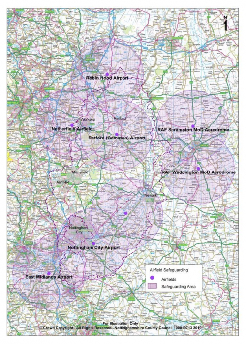
DM10: Airfield Safeguarding
Introduction
5.105. Mineral extraction sites that are restored to open water can increase the risk of bird-strike to aircraft if they are located near airfields. Although bird strike is considered to be the main risk to aviation safety from minerals development, the risk of flicker, shadow, glare and the height of any tall buildings or structures may also need to be considered. To help resolve potential conflicts, Airfield Safeguarding Areas (13km/ 8 mile radius) are designated around airports and civil and military airfields. Within these safeguarding zones, consultation with owners or operators of relevant airfields will be required in order to consider potential bird strike or other hazards.
(1) Policy DM10: Airfield Safeguarding
Proposals for minerals development within the following Airfield Safeguarding Areas will be supported where the applicant can demonstrate that the proposed extraction, restoration and after use will not result in any unacceptable adverse impacts on aviation safety:
- East Midlands Airport;
- Gamston (Retford) Airport;
- Netherthorpe Airfield;
- Nottingham City Airport;
- Robin Hood Airport Doncaster Sheffield;
- RAF Scampton MoD Aerodrome;
- RAF Syerston MoD Aerodrome;
- RAF Waddington MoD Aerodrome.
Any new airfield safeguarding area notified to the Council during the Plan period will also be safeguarded.
Justification
5.106. The purpose of airfield safeguarding is to ensure that the operation and development of civil and military airfields is not inhibited by development that could pose a hazard to aircraft or radar operation. National policy requires mineral working, restoration and after-use proposals to take account of aviation safety. The planning process therefore has an important role in preventing any unacceptable adverse impacts on aviation safety arising from minerals development.
5.107. The restoration of minerals sites to open water may lead to the creation of areas that attract roosting or loafing birds such as gulls and geese, especially when large areas of water greater than 200m across are created. This is potentially dangerous in the vicinity of airports or airfields where any increase in the number of birds can increase the overall risk of birdstrike to aircraft. However, it is possible to have water-based restoration without constituting an unacceptable risk to aviation safety through measures such as the creation of reed beds or fragmented ponds, instead of open water, which generally do not attract the flocking birds that present a bird strike hazard.
5.108. It is important to note that this policy applies to all types of mineral site restoration as risks to aviation safety are not solely associated with water-based habitats. For example, some bird species associated with bird strike can also be found on agricultural land.
5.109. Other hazards to aviation, although less common in association with minerals development, include tall buildings or structures such as chimneys, masts and pylons. Wind turbines can also cause problems due to the flicker effect of the rotating blades. Reflective surfaces such as solar panels also need to be carefully sited and angled to avoid glare.
5.110. This policy does not preclude any specific forms of restoration or after-use but seeks to ensure that aviation safety is fully considered and addressed through appropriate consultation, avoidance and mitigation. Advice Notes on the safeguarding of aerodromes have been produced by the Airport Operators' Association and General Aviation Awareness Council.
5.111. There are eight licenced safeguarded airfield areas affecting Nottinghamshire and these are identified on Plan 5. Other, non-licenced, aerodromes may be safeguarded by privately agreed consultation with the Local Planning Authority. This is called 'unofficial' safeguarding and is not obligatory under Statutory Direction. However, the County Council acknowledges the Governments advice that 'aerodrome owners should take steps to safeguard their operations' and as such Policy DM10 will also apply to these 'unofficial' safeguarded areas as recorded by Local Planning Authorities.
Plan 6: Airfield safeguarding
DM11: Planning Obligations
Introduction
5.112. To achieve sustainable development, additional planning requirements may be required to make a proposed development acceptable. The coordinated delivery of adequately funded infrastructure at the right time and in the right place is key to ensuring that local services, facilities and the transport network can cope with any added demand that arises from new minerals development.
Policy DM11: Planning Obligations
The County Council will seek to negotiate planning obligations as measures for controlling mineral operations and to secure sustainable development objectives which cannot be achieved by the use of planning conditions.
Justification
5.113. Planning obligations (also known as Section 106 agreements) are private agreements made between local authorities, developers and landowners which can be attached to a planning permission to make acceptable development which would otherwise be unacceptable in planning terms. The obligations set out in Section 106 agreements apply to the person or organisation that entered into the agreement, and any subsequent owner of the land to which the planning permission relates. This is something that any future owners will need to take in to account.
5.114. The National Planning Policy Framework provides Government guidance on the use of planning obligations. It contains three tests that planning obligations must meet:
- Necessary to make the proposed development acceptable in planning terms;
- Directly related to the proposed development;
- Fairly and reasonably related in scale and kind to the proposed development.
5.115. Circumstances where planning obligations may be sought include:
- Provision of off-site works such as highway improvements, landscape treatment and planting;
- Facilitating the preservation by record of archaeological remains;
- Contributing towards the delivery of the Nottinghamshire Local Biodiversity Action Plan targets (relevant to the site);
- Providing long-term site management (where third parties are involved);
- Flood risk management schemes.
5.116. The nature and scale of obligation requirements from a development will reflect:
- The nature and impact the development has upon strategic, local and on-site needs and requirements;
- Current infrastructure and whether the development can be accommodated by the existing provision;
- How the potential impacts of a development can be mitigated;
- Viability. In considering issues of viability the Council will have regard to the quality and value of a scheme in the context of how the development contributed towards the vision, objectives and policies for the area.
5.117. Whether obligations will be 'in kind' (where the developer builds or directly provides the infrastructure), by means of financial payments or a combination of both will depend on the nature and circumstances of the infrastructure requirement. The National Planning Policy Framework sets out that development identified in the Local Plan should not be subject to such a scale of obligations and policy burdens that their ability to be developed viably is threatened. It emphasises that developers and landowners should receive a competitive return to enable the development to be delivered.
5.118. Planning obligations can be used to address the unacceptable impacts of minerals developments but cannot be used to provide more general unrelated community benefits. As such Nottinghamshire County Council would encourage negotiated agreements between relevant minerals operators and a community as a source of funding for local benefits. These benefit packages would comprise bilateral arrangements between the main parties. Agreements would be between operators and local bodies such as Parish Councils or residents associations. The County Council cannot be party to such agreements because planning decisions must be impartial and made on planning grounds alone.
DM12: Restoration, aftercare and after-use
Introduction
5.119. It is essential that mineral extraction and restoration are properly designed at the planning application stage to ensure that both are technically and economically feasible, environmentally acceptable and that the impacts can be fully assessed.
5.120. Note: This policy should be considered along-side Policy SP2: Biodiversity-Led Restoration.
(3) Policy DM12: Restoration, aftercare and after-use
- Proposals for minerals development must include an appropriate scheme for the restoration, after care and long term after use to enable long term enhancement of the environment.
Restoration
- Restoration of minerals development should be in keeping with the character and setting of the local area and should contribute to the delivery of local objectives for habitats, biodiversity, landscape, historic environment or community use where appropriate.
-
As a minimum, restoration plans should include:
- An overall concept plan with sufficient detail to demonstrate that the scheme is feasible in both technical and economic terms and is consistent with the County Council's biodiversity-led restoration strategy; and
- Illustrative details of contouring, landscaping, phasing and any other relevant information as appropriate.
-
Mineral extraction proposals which rely on the importation of waste for restoration must:
- Include satisfactory evidence that the waste will be available over an appropriate timescale in the types and quantities assumed;
- Provide the optimum restoration solution; and
- Provide evidence that it is not practical to re-use or recycle the waste
Aftercare
- Restoration proposals will be subject to a minimum five year period of aftercare. Where proposals or elements of proposals, such as features of biodiversity interest, require a longer period of management the proposal will only be permitted if it includes details of the period of extended aftercare and how this will be achieved.
After-use
- Where proposals for the after use includes habitat creation, applicants will be required to demonstrate how the proposals contribute to the delivery of Local Biodiversity Action Plan targets and have regard to the biodiversity-led restoration approach and the opportunities identified in the National Character Area profile.
- All proposals will be required to make provision for the retention or replacement of soils, as appropriate, and for any necessary drainage, access, hedges and fences.
- The after-use will be required to have regard to the wider context of the site, in terms of the character of the surrounding landscape and historic environment and existing land uses in the area.
- Where opportunities arise, after-use proposals should provide benefits to the local and wider community.
Justification
5.121. National policy requires local planning authorities to ensure that worked land is reclaimed at the earliest opportunity and that high-quality restoration and aftercare takes place.
5.122. Although mineral working is a temporary land use, worked sites which are not appropriately restored can result in permanent adverse impacts on the environment. It is essential that the detailed restoration proposals for minerals development are properly considered at the application stage to minimise impacts and ensure long term benefits are secured.
5.123. The overall restoration proposal also establishes the long-term potential of the land for a wide range of after-uses that can benefit the local and/or wider community, including employment, conservation, recreation, forestry and agricultural uses as well as improved public access for all users. The phasing of operations to achieve restoration at the earliest opportunity is an important factor influencing the acceptability of minerals extraction to local residents.
5.124. Achieving high quality restoration must be integral to any proposals for minerals development. At the national level, Natural England has published a series of National Character Area profiles which suggest where action can be best targeted to conserve and improve the natural environment.
5.125. The 'Bigger and Better' document prepared by the RSPB in partnership with other environmental organisations, promotes a strategic, landscape scale approach to biodiversity-led minerals restoration which will help to establish a coherent and resilient network of wetlands across the whole of the Trent and Tame River Valleys. In addition, a more detailed concept plan has been developed for the section of the Trent Valley between Newark and South Clifton which is intended to complement the existing positive approach towards future mineral sites restoration in this area.
5.126. The Council's biodiversity-led restoration approach is based on the biodiversity opportunities in Nottinghamshire which assist in maximising the potential value of minerals restoration by carefully planning which habitats can be created, and where. The restoration process will be required to ensure that the priority habitats identified in the Nottinghamshire Local Biodiversity Action Plan are created or enhanced, where appropriate.
5.127. Most mineral workings are on agricultural land. In general where the best and most versatile land is taken for mineral extraction, it is important that the potential for land to be returned to an after-use which maintains the quality of the land and soil is maintained through an appropriate landform and or soil profiles.
5.128. The Landscape Character Assessments covering Nottinghamshire identify specific features of the different Landscape Character Areas within the County. This information can then be used to assist in the designing of restoration schemes.
5.129. Proposals for minerals development should be accompanied by a restoration scheme that provides comprehensive details of the order and timing of phases of mineral working, restoration and of the final main after uses. Where possible the proposed scheme should incorporate some element of flexibility to take account of changing circumstances during the life of the development and beyond. It should aim to integrate and facilitate the delivery of any relevant mitigation measures, as identified in assessments undertaken to support the planning application. It is strongly advised that these matters are discussed with the Mineral Planning Authority at the pre-application stage, and where possible involve input from relevant key stakeholders to resolve any potential conflicts of interest.
5.130. Soils must be adequately protected and maintained throughout the life of the development, particularly if a site comprises land that qualifies as best and most versatile agricultural land (see Policy DM3: Agricultural land and soil quality). Where necessary, proposals for minerals development should be supported by a site specific Land Classification Survey, undertaken by an independent expert to determine the grading and agricultural value of the proposed site. The survey should incorporate a report/statement of physical characteristics, providing detailed information about the soils, subsoils and overburden within the boundaries of the site. Where the proposed after use is to be one which requires little or no soil, e.g. a lake or a nature reserve requiring impoverished soil resources, it would be better for soils to be removed from site and used beneficially elsewhere.
5.131. In some cases, materials (such as inert waste) will need to be imported to ensure that the site can be restored and returned to a beneficial after-use. Phased restoration of a site may require an adequate and timely supply of suitable material in order to ensure that the development can proceed on schedule. However, inert fill material may not necessarily be available in the required quantities and timescales, as the introduction and application of Landfill Tax has reduced the amount of inert material available. In addition, Government encourages the recycling and use of construction and demolition waste as an alternative to primary aggregates. Developers will be required to demonstrate that materials to be imported for restoration purposes are both suitable (based on the advice of the Environment Agency) and are available in sufficient quantity and when needed to achieve the proposed restoration scheme.
5.132. It should be noted that whilst a mineral extraction activity in one location may be appropriate, if the restoration/infill scheme intends to use waste material, then this activity may not be appropriate in that location, for example if there are amenity issues for nearby residents. Where waste material is to be imported, an Environmental Permit from the Environment Agency will be required. Where restoration involves the use of extractive waste (i.e. waste produced through the mineral extraction process, not imported) then the operator may be required to apply for a Mining Waste Environmental Permit from the Environment Agency.
5.133. Minerals development will be expected to contribute, where appropriate, to the green infrastructure (strategic networks of well-planned, multi-functional spaces) of Nottinghamshire, particularly through the restoration and after-use of minerals development sites.
5.134. After the mineral has been extracted and the stripped soils returned, the aftercare period is the time when the site is prepared for the agreed after-use. Aftercare can include the processes of cultivating, fertilising, planting, draining and otherwise treating the land. The minerals operator is normally still responsible for the site at this time. An appropriate period of aftercare is needed to ensure mineral sites are restored to a standard suitable for their intended after-use.
5.135. Different after-uses may require different periods of aftercare. The statutory aftercare period is 5 years or such other maximum period as may be prescribed and some uses such as nature conservation may benefit from an aftercare period of up to 20 years or more, whilst agriculture may only need a 5 year aftercare period. Where possible and where appropriate, voluntary extended aftercare periods will be negotiated for those uses that would benefit from such longer periods and will be secured by condition.
5.136. It is important that management responsibilities are identified and agreed between the developer and those taking on the aftercare of the site to ensure that the proposed after-use can and will be delivered. Developers will be encouraged to enter into planning agreements to ensure that the appropriate aftercare provisions remain in effect for the required aftercare period.
5.137. All restoration proposals should take into account the relevant District/Borough Local Plans and where appropriate contribute to the delivery of those Plans. Minerals developers will also be encouraged to involve local communities and parish councils when considering options for restoration and aftercare.
DM13: Incidental Mineral Extraction
Introduction
5.138. In principle, recovering minerals as an incidental element of another development proposal promotes sustainable development by helping to conserve mineral resources that might otherwise be lost.
(1) Policy DM13: Incidental Mineral Extraction
- Planning applications for the extraction of minerals as a necessary element of other development proposals on the same site will be supported where it can be demonstrated that the scale and duration of the mineral extraction does not result in adverse environmental impacts and that it brings environmental and other benefits to the development it is incidental to.
- Where planning permission is granted, conditions will be imposed to ensure that the site can be adequately restored to a satisfactory after-use should the main development be delayed or not implemented.
Justification
5.139. District/Borough Councils within Nottinghamshire should advise the County Council on proposals, such as ornamental lakes and major built development, which involve the excavation and removal of significant quantities of soils, overburden and mineral. Failure to do so may result in planning permission being granted without taking into account potential mineral planning issues. Developers submitting proposals to District/Borough Councils are likewise encouraged to consult the County Council at the pre-application stage where they expect incidental mineral extraction to be necessary.
5.140. In many cases the planning application for the main development may be determined by the District/Borough Council, and, except where quantities are very small, the mineral extraction may need to take the form of a separate planning application to be determined by the County Council. In these cases, in order to ensure that both proposals are compatible, it is important to consider both planning applications at the same time. Interim reclamation proposals must be included to ensure that the primary development proposals are not delayed, or fail to be implemented.
5.141. Incidental mineral extraction is not precisely defined in terms of quantity of mineral worked or duration. It does not, however, apply to mineral development simply because it is small scale or short term. If mineral extraction is a significant reason for justifying or promoting the development, the proposal will need to be assessed against the relevant policies applicable to the mineral being worked.
DM14: Irrigation Lagoons
Introduction
5.142. Proposals to construct irrigation lagoons within agricultural land can involve the extraction of minerals to create the lagoon. The mineral is usually taken offsite for processing at a nearby quarry. Providing there is evidence of genuine agricultural benefits then the mineral extraction can normally be regarded as incidental.
Policy DM14: Irrigation Lagoons
Proposals for mineral extraction to create or extend irrigation lagoons will be supported where:
- There is satisfactory evidence that they will provide significant benefits to agricultural productivity;
- They can be worked without any unacceptable environmental impacts;
- The irrigation lagoon is landscaped and treated to maximise its potential for enhancing the landscape character and/or biodiversity.
- The irrigation lagoon is of a scale or degree that does not impact on the development of permitted or allocated mineral extraction sites.
Justification
5.143. The development of irrigation lagoons is often classed as 'permitted development' and would not require planning permission unless the mineral is taken off-site.
5.144. Sand and gravel deposits are technically very suited for this purpose because of the normally high water table level and relatively rapid recharge after the water is abstracted for irrigation. The cost of creating the lagoon is also likely to be offset by the value of the mineral. The main planning issues will generally comprise traffic during construction, the impact on archaeological sites, and the long term landscape impact of the lagoon. Wildlife impact is less likely to be an issue, as these lagoons tend to be sited within arable fields.
5.145. Whilst the purpose of these lagoons is to provide irrigation, it is important that they are shaped and landscaped to blend in with and, where possible, enhance the landscape character of the area, including biodiversity. The standard rectangular reservoir should be avoided, as this will generally detract from the area.
5.146. It should be noted that irrigation lagoons will usually require a water abstraction licence from the Environment Agency. In certain parts of Nottinghamshire, particularly in the River Idle and River Torne catchment areas, no new water abstraction is allowed. Whether abstraction is allowed in the proposed area (and similarly whether the applicant has started to pursue the securing of a licence) could be an indication of a genuine agricultural purpose for the lagoon and thus could be used as evidence referred to in part a) of the policy.
DM15: Borrow Pits
Introduction
5.147. The term 'borrow pit' is applied to a temporary mineral working supplying material for use solely in a specific construction project, particularly roads.
5.148. Borrow pits are typically located next to the construction site, and in the ideal situation are soon backfilled with waste materials, such as soft clay, that often have to be removed from the construction area – hence the material excavated is 'borrowed'. Normally, large quantities of material, mainly bulk fill, are required over a short time.
Proposals for borrow pits will be supported where:
- They are adjacent to or close to the project/s they are intended to serve;
- They are time limited to the life of the project and material is to be used only for the specified project;
- They can be worked and reclaimed without any unacceptable environmental impacts;
- There are overriding environmental or other benefits compared to obtaining materials from alternative sources;
- Proposals provide for appropriate restoration measures which include full use of surplus spoil from the project.
Justification
5.149. With the exception of small borrow pits developed within the boundary of the construction sites including highways and railways, planning permission is required. Proposals for borrow pits will be treated in the same way as any other mineral extraction scheme. This means that borrow pits must be justified in terms of being the most suitable source of material to meet demand, and that appropriate environmental safeguards covering both working and restoration are included.
5.150. Advance planning is essential to ensure that the borrow pit can be developed within the timescales required. For example, if archaeological remains are present these may require a full and lengthy investigation before any mineral can be extracted. Submitting proposals after contracts are let is unlikely to allow sufficient time to resolve such complications. Urgency of need cannot be an overriding factor in the treatment of archaeological remains and other similar environmental factors.
5.151. It is important to ensure that borrow pits only supply the construction project intended. Therefore in granting planning permission for borrow pits, the County Council will take appropriate measures to control access and routeing, and permission will be time limited to the life of the construction project.
5.152. In considering 'need', the quantities and specifications of materials required for the construction project will be assessed in the context of the level and location of existing permitted reserves. Minerals won from borrow pits contribute to the County's aggregate requirements and may help to avoid the use of better quality reserves from established quarries.
5.153. In general, it should usually be possible to meet requirements from local established quarries or from waste materials and the use of secondary aggregates. In such circumstances borrow pits can normally only be justified where they offer clear environmental gains over alternative sources of supply.
5.154. For example, where borrow pits are adjacent to construction sites the most obvious environmental benefits will be the avoidance of heavy traffic on public highways. There will also be significant economic and energy savings because of the reduced haulage costs.
5.155. These short-term gains could be offset if the borrow pit is not properly reclaimed, or it is inappropriately located. For example, a water area adjacent to a major highway may have limited recreational potential because of access problems and/ or traffic noise. Where possible infilling with waste material from the construction project will normally be the preferred option.
DM16: Associated Industrial Development
Introduction
5.156. The Town and Country Planning (General Permitted Development) (England) Order 2015 allows certain types of ancillary development to be located within minerals workings subject to prior approval from the Minerals Planning Authority. This relates to the installation, maintenance, repair and replacement of plant, machinery or structures that are essential to the minerals operation. Various criteria relating to the height and appearance of buildings and structures and other restrictions may apply. All other industrial development will require planning permission in the normal way.
Policy DM16: Associated Industrial Development
Proposals for associated industrial development on or adjacent to mineral extraction sites will be required to demonstrate that they are clearly related to and linked to the life of the site.
Justification
5.157. Associated industrial development broadly comprises industrial processes which largely depend on the mineral worked from the related mine or quarry, such as ready mixed concrete plants associated with sand and gravel quarries.
5.158. Proposals for associated industrial development will only be permitted where it can be shown that there are clear overall environmental advantages in a close link between the industrial and extractive operations. Particular regard will be given to environmental and transport implications, and the likely duration of working.
5.159. The continued use of such industrial development following exhaustion of the mineral reserve means it will become dependent upon the import of raw materials. This usually involves significant movements of heavy goods vehicles and will therefore normally be resisted.
5.160. Any planning permission for associated industrial development will be time limited to expire on the cessation of working from the associated extraction area.
DM17: Mineral Exploration
Introduction
5.161. Exploration is essential to prove the existence and extent of all types of mineral resources. Prior to development, it is necessary to ensure that a resource is economically viable and to determine how it can be worked. Mineral exploration is a temporary activity and certain types and scales of development of this nature are classed as 'permitted development' under the General Permitted Development Order (meaning that planning permission is not required). However, where the mineral exploration is not classed as 'permitted' and planning permission is sought, it is important for safeguards to be in place to minimise the environmental, amenity and long-term impacts of the development.
(1) Policy DM17: Mineral Exploration
Proposals for mineral exploration will be permitted, subject to satisfactory environmental, amenity and restoration safeguards.
Justification
5.162. There are three main methods of mineral exploration; geophysical surveys, trial pits and boreholes:
Geophysical surveys
5.163. Seismic surveys are the most common type of geophysical survey, especially in the exploration of coal and oil. Whilst these surveys can provide useful information about the underlying geological structure, they do not prove the existence of mineral resources.
5.164. Most Seismic surveys have little environmental impact. However, noise and vibration can raise concerns when carried out in sensitive areas. This is especially the case when shot hole drilling is used and/or where surveys are carried out over a prolonged period. Particular concerns are the potential impacts on the local historic and natural environment that could occur as a result of survey work. Applicants are encouraged to contact the County Council prior to undertaking surveys.
5.165. Most seismic surveys have permitted development rights but there are several exceptions relating to sensitive areas, proximity to buildings, size of the explosive charge and the duration of operations. In these cases, planning permission is required. In any event, operators are encouraged to notify local residents at an early stage, prior to surveys being carried out to allay concerns and unnecessary fears.
Trial pits and shallow boreholes
5.166. Trial pits and shallow boreholes are methods of surface mineral exploration which obtain data on the depth, extent and quality of the mineral, the make-up of overburden and hydrological data. After the information is recorded, the pits are backfilled and reinstated.
5.167. As with geophysical surveys, concerns are often raised regarding the impact that digging shallow pits may have on the archaeology, however, these pits can provide an ideal opportunity to evaluate the site's archaeology at an early stage and developers are encouraged to involve archaeologists during this exploration phase.
5.168. Due to the short duration of these operations, it is very rare that the Minerals Planning Authority will have to be notified, or planning permission be obtained. However, exceptions to this include operations in close proximity to buildings and operations in environmentally sensitive locations. There are also limits on the intensity of drilling, the use of explosives and the heights of rigs. Operations are encouraged to consult the County Council where there are doubts over the planning situation.
Deep boreholes
5.169. In Nottinghamshire deep boreholes, are used mainly in the exploration of coal, oil and gas.
5.170. A hard base, normally comprising crushed limestone, is required for the drilling rig and associated equipment. Supporting equipment includes mud pits, pipe racks, pumps and cabins. The environmental implications of deep borehole drilling are therefore much greater than those for the other exploration methods noted above.
5.171. The main considerations associated with deep boreholes include visual impact, noise, access, water pollution and directional drilling.
[1] A candidate site is one which has been put forward for designation but not confirmed.
[2] Circular 06/2005
[3] 'Aggregates and Archaeology in Nottinghamshire' David Knight and Ursilla Spence